You are here: Home > Network List > RV - Regional Alberta Seismic Observatory for Earthquake Studies Network Stations List
> Station LGPLA Lodgepole, Alberta > Earthquake Result Viewer
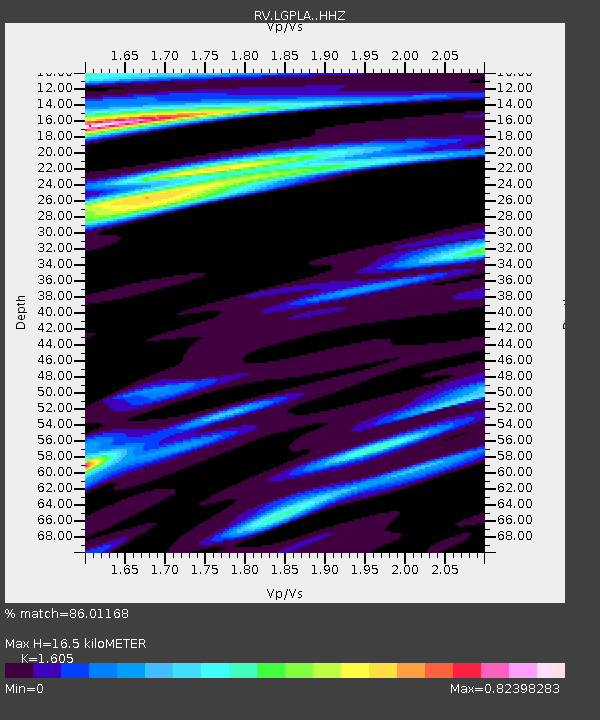
LGPLA Lodgepole, Alberta - Earthquake Result Viewer
| Earthquake location: |
Jan Mayen Island Region |
| Earthquake latitude/longitude: |
71.6/-11.2 |
| Earthquake time(UTC): |
2018/11/09 (313) 01:49:40 GMT |
| Earthquake Depth: |
10 km |
| Earthquake Magnitude: |
6.8 Mww |
| Earthquake Catalog/Contributor: |
NEIC PDE/us |
|
| Network: |
RV Regional Alberta Seismic Observatory for Earthquake Studies Network |
| Station: |
LGPLA Lodgepole, Alberta |
| Lat/Lon: |
53.12 N/115.36 W |
| Elevation: |
877 m |
|
| Distance: |
44.8 deg |
| Az: |
303.879 deg |
| Baz: |
25.905 deg |
| Ray Param: |
0.071719676 |
| Estimated Moho Depth: |
16.5 km |
| Estimated Crust Vp/Vs: |
1.61 |
| Assumed Crust Vp: |
6.426 km/s |
| Estimated Crust Vs: |
4.004 km/s |
| Estimated Crust Poisson's Ratio: |
0.18 |
|
| Radial Match: |
86.01168 % |
| Radial Bump: |
269 |
| Transverse Match: |
54.506447 % |
| Transverse Bump: |
400 |
| SOD ConfigId: |
13570011 |
| Insert Time: |
2019-05-01 18:37:33.403 +0000 |
| GWidth: |
2.5 |
| Max Bumps: |
400 |
| Tol: |
0.001 |
|

Signal To Noise
| Channel | StoN | STA | LTA |
| RV:LGPLA: :HHZ:20181109T01:57:22.650012Z | 10.110408 | 2.8092204E-6 | 2.778543E-7 |
| RV:LGPLA: :HHN:20181109T01:57:22.650012Z | 2.9238615 | 8.992689E-7 | 3.075621E-7 |
| RV:LGPLA: :HHE:20181109T01:57:22.650012Z | 1.6902251 | 8.2709835E-7 | 4.8934214E-7 |
| Arrivals |
| Ps | 1.7 SECOND |
| PpPs | 6.2 SECOND |
| PsPs/PpSs | 7.9 SECOND |


