You are here: Home > Network List > TA - USArray Transportable Network (new EarthScope stations) Stations List
> Station B20K Meade River, AK, USA > Earthquake Result Viewer
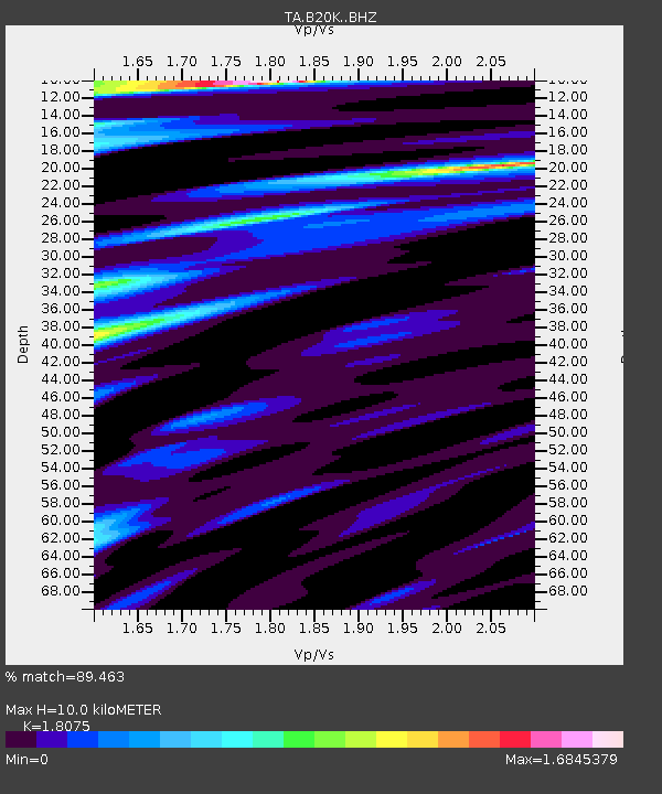
B20K Meade River, AK, USA - Earthquake Result Viewer
| Earthquake location: |
Jan Mayen Island Region |
| Earthquake latitude/longitude: |
71.6/-11.2 |
| Earthquake time(UTC): |
2018/11/09 (313) 01:49:40 GMT |
| Earthquake Depth: |
10 km |
| Earthquake Magnitude: |
6.8 Mww |
| Earthquake Catalog/Contributor: |
NEIC PDE/us |
|
| Network: |
TA USArray Transportable Network (new EarthScope stations) |
| Station: |
B20K Meade River, AK, USA |
| Lat/Lon: |
70.01 N/157.16 W |
| Elevation: |
75 m |
|
| Distance: |
36.9 deg |
| Az: |
341.258 deg |
| Baz: |
17.237 deg |
| Ray Param: |
0.0764536 |
| Estimated Moho Depth: |
10.0 km |
| Estimated Crust Vp/Vs: |
1.81 |
| Assumed Crust Vp: |
6.048 km/s |
| Estimated Crust Vs: |
3.346 km/s |
| Estimated Crust Poisson's Ratio: |
0.28 |
|
| Radial Match: |
89.463 % |
| Radial Bump: |
400 |
| Transverse Match: |
77.61145 % |
| Transverse Bump: |
400 |
| SOD ConfigId: |
13570011 |
| Insert Time: |
2019-05-01 18:37:56.759 +0000 |
| GWidth: |
2.5 |
| Max Bumps: |
400 |
| Tol: |
0.001 |
|

Signal To Noise
| Channel | StoN | STA | LTA |
| TA:B20K: :BHZ:20181109T01:56:17.575Z | 14.093023 | 2.7915426E-6 | 1.9807976E-7 |
| TA:B20K: :BHN:20181109T01:56:17.575Z | 3.9009485 | 1.1833273E-6 | 3.0334346E-7 |
| TA:B20K: :BHE:20181109T01:56:17.575Z | 1.7611094 | 4.316616E-7 | 2.4510777E-7 |
| Arrivals |
| Ps | 1.4 SECOND |
| PpPs | 4.4 SECOND |
| PsPs/PpSs | 5.8 SECOND |


