G04A Mulino, OR, USA - Earthquake Result Viewer
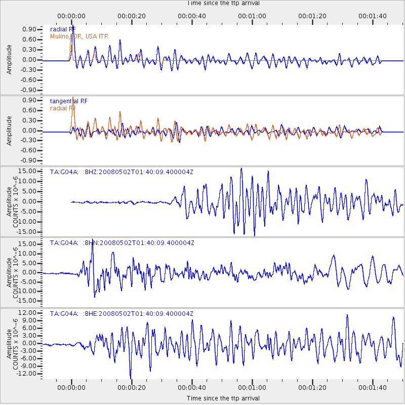
Earthquake location: Andreanof Islands, Aleutian Is.
Earthquake latitude/longitude: 51.9/-177.5
Earthquake time(UTC): 2008/05/02 (123) 01:33:37 GMT
Earthquake Depth: 14 km
Earthquake Magnitude: 6.3 MB, 6.8 MS, 6.6 MW, 6.6 MW
Earthquake Catalog/Contributor: WHDF/NEIC
Network: TA USArray Transportable Network (new EarthScope stations)
Station: G04A Mulino, OR, USA
Lat/Lon: 45.21 N/122.48 W
Elevation: 273 m
Distance: 36.3 deg
Az: 78.218 deg
Baz: 300.832 deg
Ray Param: 0.076749936
Estimated Moho Depth: 51.75 km
Estimated Crust Vp/Vs: 1.97
Assumed Crust Vp: 6.566 km/s
Estimated Crust Vs: 3.342 km/s
Estimated Crust Poisson's Ratio: 0.33
Radial Match: 80.45336 %
Radial Bump: 400
Transverse Match: 60.534733 %
Transverse Bump: 400
SOD ConfigId: 2504
Insert Time: 2010-03-06 17:41:46.080 +0000
GWidth: 2.5
Max Bumps: 400
Tol: 0.001

Signal To Noise

ChannelStoNSTALTA
TA:G04A: :BHN:20080502T01:40:09.400004Z15.64981.8291803E-61.1688202E-7
TA:G04A: :BHE:20080502T01:40:09.400004Z2.89621696.832067E-72.3589625E-7
TA:G04A: :BHZ:20080502T01:40:09.400004Z3.43237389.627172E-72.8048143E-7
Arrivals
Ps8.2 SECOND
PpPs22 SECOND
PsPs/PpSs30 SECOND