You are here: Home > Network List > TA - USArray Transportable Network (new EarthScope stations) Stations List
> Station D17K Noatak River, AK, USA > Earthquake Result Viewer
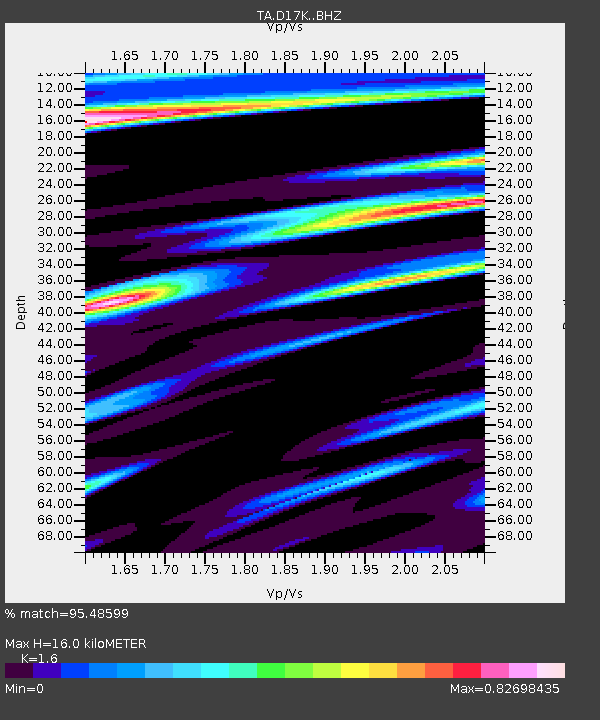
D17K Noatak River, AK, USA - Earthquake Result Viewer
| Earthquake location: |
Jan Mayen Island Region |
| Earthquake latitude/longitude: |
71.6/-11.2 |
| Earthquake time(UTC): |
2018/11/09 (313) 01:49:40 GMT |
| Earthquake Depth: |
10 km |
| Earthquake Magnitude: |
6.8 Mww |
| Earthquake Catalog/Contributor: |
NEIC PDE/us |
|
| Network: |
TA USArray Transportable Network (new EarthScope stations) |
| Station: |
D17K Noatak River, AK, USA |
| Lat/Lon: |
67.70 N/163.08 W |
| Elevation: |
172 m |
|
| Distance: |
39.7 deg |
| Az: |
343.609 deg |
| Baz: |
13.563 deg |
| Ray Param: |
0.07485587 |
| Estimated Moho Depth: |
16.0 km |
| Estimated Crust Vp/Vs: |
1.60 |
| Assumed Crust Vp: |
6.276 km/s |
| Estimated Crust Vs: |
3.922 km/s |
| Estimated Crust Poisson's Ratio: |
0.18 |
|
| Radial Match: |
95.48599 % |
| Radial Bump: |
380 |
| Transverse Match: |
80.21239 % |
| Transverse Bump: |
400 |
| SOD ConfigId: |
13570011 |
| Insert Time: |
2019-05-01 18:38:06.714 +0000 |
| GWidth: |
2.5 |
| Max Bumps: |
400 |
| Tol: |
0.001 |
|

Signal To Noise
| Channel | StoN | STA | LTA |
| TA:D17K: :BHZ:20181109T01:56:41.175006Z | 19.15651 | 2.2851711E-6 | 1.1928954E-7 |
| TA:D17K: :BHN:20181109T01:56:41.175006Z | 7.214882 | 9.44124E-7 | 1.3085786E-7 |
| TA:D17K: :BHE:20181109T01:56:41.175006Z | 5.334499 | 7.9571544E-7 | 1.4916405E-7 |
| Arrivals |
| Ps | 1.6 SECOND |
| PpPs | 6.1 SECOND |
| PsPs/PpSs | 7.8 SECOND |


