You are here: Home > Network List > TA - USArray Transportable Network (new EarthScope stations) Stations List
> Station F19K Shaleruckik Mountain, AK, USA > Earthquake Result Viewer
F19K Shaleruckik Mountain, AK, USA - Earthquake Result Viewer
| Earthquake location: |
Jan Mayen Island Region |
| Earthquake latitude/longitude: |
71.6/-11.2 |
| Earthquake time(UTC): |
2018/11/09 (313) 01:49:40 GMT |
| Earthquake Depth: |
10 km |
| Earthquake Magnitude: |
6.8 Mww |
| Earthquake Catalog/Contributor: |
NEIC PDE/us |
|
| Network: |
TA USArray Transportable Network (new EarthScope stations) |
| Station: |
F19K Shaleruckik Mountain, AK, USA |
| Lat/Lon: |
66.83 N/157.77 W |
| Elevation: |
161 m |
|
| Distance: |
40.0 deg |
| Az: |
340.148 deg |
| Baz: |
15.798 deg |
| Ray Param: |
0.07466397 |
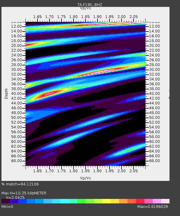
| Estimated Moho Depth: |
10.25 km |
| Estimated Crust Vp/Vs: |
2.04 |
| Assumed Crust Vp: |
6.577 km/s |
| Estimated Crust Vs: |
3.22 km/s |
| Estimated Crust Poisson's Ratio: |
0.34 |
|
| Radial Match: |
94.12106 % |
| Radial Bump: |
347 |
| Transverse Match: |
60.299892 % |
| Transverse Bump: |
400 |
| SOD ConfigId: |
13570011 |
| Insert Time: |
2019-05-01 18:38:26.079 +0000 |
| GWidth: |
2.5 |
| Max Bumps: |
400 |
| Tol: |
0.001 |
|

Signal To Noise
| Channel | StoN | STA | LTA |
| TA:F19K: :BHZ:20181109T01:56:43.800006Z | 14.34816 | 2.1734106E-6 | 1.5147661E-7 |
| TA:F19K: :BHN:20181109T01:56:43.800006Z | 7.6742234 | 1.3578433E-6 | 1.769356E-7 |
| TA:F19K: :BHE:20181109T01:56:43.800006Z | 1.9239144 | 2.5828302E-7 | 1.342487E-7 |
| Arrivals |
| Ps | 1.7 SECOND |
| PpPs | 4.4 SECOND |
| PsPs/PpSs | 6.2 SECOND |


