You are here: Home > Network List > TA - USArray Transportable Network (new EarthScope stations) Stations List
> Station F21K Alatna River, AK, USA > Earthquake Result Viewer
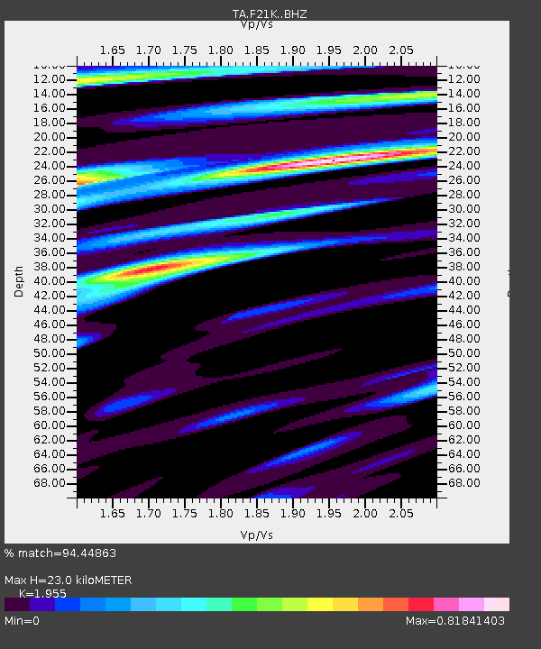
F21K Alatna River, AK, USA - Earthquake Result Viewer
| Earthquake location: |
Jan Mayen Island Region |
| Earthquake latitude/longitude: |
71.6/-11.2 |
| Earthquake time(UTC): |
2018/11/09 (313) 01:49:40 GMT |
| Earthquake Depth: |
10 km |
| Earthquake Magnitude: |
6.8 Mww |
| Earthquake Catalog/Contributor: |
NEIC PDE/us |
|
| Network: |
TA USArray Transportable Network (new EarthScope stations) |
| Station: |
F21K Alatna River, AK, USA |
| Lat/Lon: |
67.22 N/153.48 W |
| Elevation: |
597 m |
|
| Distance: |
39.1 deg |
| Az: |
337.796 deg |
| Baz: |
17.93 deg |
| Ray Param: |
0.075170405 |
| Estimated Moho Depth: |
23.0 km |
| Estimated Crust Vp/Vs: |
1.96 |
| Assumed Crust Vp: |
6.455 km/s |
| Estimated Crust Vs: |
3.302 km/s |
| Estimated Crust Poisson's Ratio: |
0.32 |
|
| Radial Match: |
94.44863 % |
| Radial Bump: |
338 |
| Transverse Match: |
75.9376 % |
| Transverse Bump: |
400 |
| SOD ConfigId: |
13570011 |
| Insert Time: |
2019-05-01 18:38:27.213 +0000 |
| GWidth: |
2.5 |
| Max Bumps: |
400 |
| Tol: |
0.001 |
|

Signal To Noise
| Channel | StoN | STA | LTA |
| TA:F21K: :BHZ:20181109T01:56:36.624988Z | 17.900827 | 2.4410754E-6 | 1.3636662E-7 |
| TA:F21K: :BHN:20181109T01:56:36.624988Z | 17.22587 | 1.5475588E-6 | 8.983922E-8 |
| TA:F21K: :BHE:20181109T01:56:36.624988Z | 7.2374725 | 6.680008E-7 | 9.229752E-8 |
| Arrivals |
| Ps | 3.6 SECOND |
| PpPs | 9.9 SECOND |
| PsPs/PpSs | 13 SECOND |


