You are here: Home > Network List > TA - USArray Transportable Network (new EarthScope stations) Stations List
> Station F30M Barrier River, YT, CAN > Earthquake Result Viewer
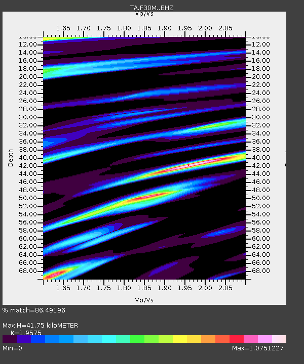
F30M Barrier River, YT, CAN - Earthquake Result Viewer
| Earthquake location: |
Jan Mayen Island Region |
| Earthquake latitude/longitude: |
71.6/-11.2 |
| Earthquake time(UTC): |
2018/11/09 (313) 01:49:40 GMT |
| Earthquake Depth: |
10 km |
| Earthquake Magnitude: |
6.8 Mww |
| Earthquake Catalog/Contributor: |
NEIC PDE/us |
|
| Network: |
TA USArray Transportable Network (new EarthScope stations) |
| Station: |
F30M Barrier River, YT, CAN |
| Lat/Lon: |
67.61 N/135.79 W |
| Elevation: |
414 m |
|
| Distance: |
36.2 deg |
| Az: |
327.694 deg |
| Baz: |
26.264 deg |
| Ray Param: |
0.076818064 |
| Estimated Moho Depth: |
41.75 km |
| Estimated Crust Vp/Vs: |
1.96 |
| Assumed Crust Vp: |
6.171 km/s |
| Estimated Crust Vs: |
3.153 km/s |
| Estimated Crust Poisson's Ratio: |
0.32 |
|
| Radial Match: |
86.49196 % |
| Radial Bump: |
399 |
| Transverse Match: |
76.392334 % |
| Transverse Bump: |
400 |
| SOD ConfigId: |
13570011 |
| Insert Time: |
2019-05-01 18:38:30.450 +0000 |
| GWidth: |
2.5 |
| Max Bumps: |
400 |
| Tol: |
0.001 |
|

Signal To Noise
| Channel | StoN | STA | LTA |
| TA:F30M: :BHZ:20181109T01:56:11.874988Z | 12.182791 | 2.9206428E-6 | 2.3973513E-7 |
| TA:F30M: :BHN:20181109T01:56:11.874988Z | 3.495649 | 1.2888205E-6 | 3.6869278E-7 |
| TA:F30M: :BHE:20181109T01:56:11.874988Z | 5.8735495 | 1.228865E-6 | 2.0922016E-7 |
| Arrivals |
| Ps | 6.9 SECOND |
| PpPs | 19 SECOND |
| PsPs/PpSs | 26 SECOND |


