You are here: Home > Network List > TA - USArray Transportable Network (new EarthScope stations) Stations List
> Station H27K Steamboat Mountain, AK, USA > Earthquake Result Viewer
H27K Steamboat Mountain, AK, USA - Earthquake Result Viewer
| Earthquake location: |
Jan Mayen Island Region |
| Earthquake latitude/longitude: |
71.6/-11.2 |
| Earthquake time(UTC): |
2018/11/09 (313) 01:49:40 GMT |
| Earthquake Depth: |
10 km |
| Earthquake Magnitude: |
6.8 Mww |
| Earthquake Catalog/Contributor: |
NEIC PDE/us |
|
| Network: |
TA USArray Transportable Network (new EarthScope stations) |
| Station: |
H27K Steamboat Mountain, AK, USA |
| Lat/Lon: |
66.23 N/141.53 W |
| Elevation: |
786 m |
|
| Distance: |
38.4 deg |
| Az: |
330.138 deg |
| Baz: |
22.932 deg |
| Ray Param: |
0.07559132 |
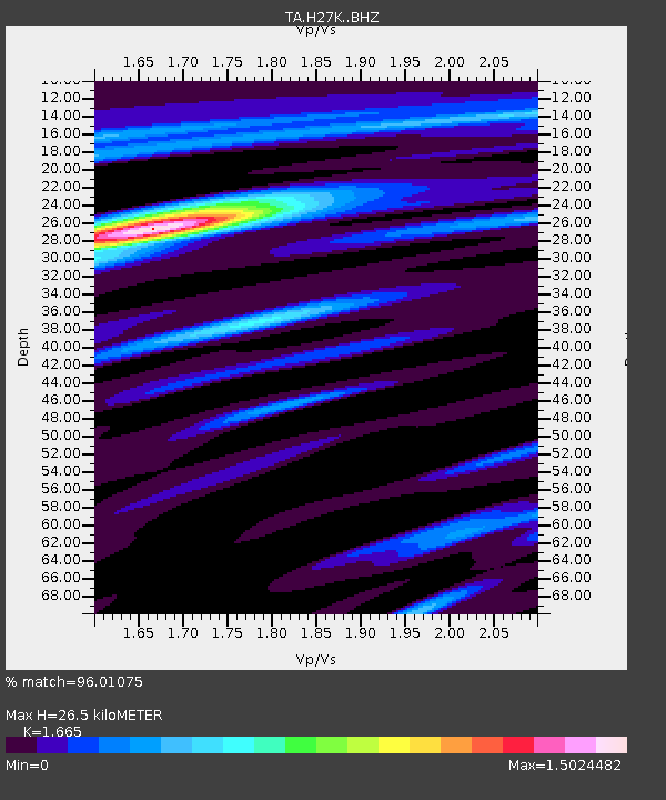
| Estimated Moho Depth: |
26.5 km |
| Estimated Crust Vp/Vs: |
1.66 |
| Assumed Crust Vp: |
6.577 km/s |
| Estimated Crust Vs: |
3.95 km/s |
| Estimated Crust Poisson's Ratio: |
0.22 |
|
| Radial Match: |
96.01075 % |
| Radial Bump: |
377 |
| Transverse Match: |
80.76495 % |
| Transverse Bump: |
400 |
| SOD ConfigId: |
13570011 |
| Insert Time: |
2019-05-01 18:38:52.828 +0000 |
| GWidth: |
2.5 |
| Max Bumps: |
400 |
| Tol: |
0.001 |
|

Signal To Noise
| Channel | StoN | STA | LTA |
| TA:H27K: :BHZ:20181109T01:56:30.525012Z | 13.908974 | 2.5270467E-6 | 1.8168463E-7 |
| TA:H27K: :BHN:20181109T01:56:30.525012Z | 10.14167 | 1.4712673E-6 | 1.450715E-7 |
| TA:H27K: :BHE:20181109T01:56:30.525012Z | 5.5590158 | 9.4986757E-7 | 1.7086974E-7 |
| Arrivals |
| Ps | 2.9 SECOND |
| PpPs | 9.9 SECOND |
| PsPs/PpSs | 13 SECOND |


