You are here: Home > Network List > TA - USArray Transportable Network (new EarthScope stations) Stations List
> Station H29M Whitestone, YT, CAN > Earthquake Result Viewer
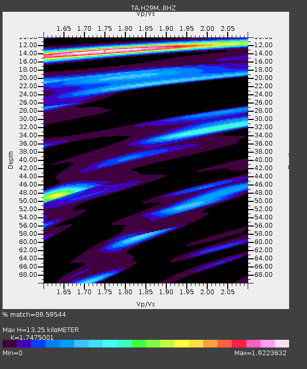
H29M Whitestone, YT, CAN - Earthquake Result Viewer
| Earthquake location: |
Jan Mayen Island Region |
| Earthquake latitude/longitude: |
71.6/-11.2 |
| Earthquake time(UTC): |
2018/11/09 (313) 01:49:40 GMT |
| Earthquake Depth: |
10 km |
| Earthquake Magnitude: |
6.8 Mww |
| Earthquake Catalog/Contributor: |
NEIC PDE/us |
|
| Network: |
TA USArray Transportable Network (new EarthScope stations) |
| Station: |
H29M Whitestone, YT, CAN |
| Lat/Lon: |
66.22 N/138.37 W |
| Elevation: |
480 m |
|
| Distance: |
37.9 deg |
| Az: |
328.231 deg |
| Baz: |
24.319 deg |
| Ray Param: |
0.07588222 |
| Estimated Moho Depth: |
13.25 km |
| Estimated Crust Vp/Vs: |
1.75 |
| Assumed Crust Vp: |
6.577 km/s |
| Estimated Crust Vs: |
3.763 km/s |
| Estimated Crust Poisson's Ratio: |
0.26 |
|
| Radial Match: |
89.59544 % |
| Radial Bump: |
400 |
| Transverse Match: |
63.78419 % |
| Transverse Bump: |
400 |
| SOD ConfigId: |
13570011 |
| Insert Time: |
2019-05-01 18:38:53.949 +0000 |
| GWidth: |
2.5 |
| Max Bumps: |
400 |
| Tol: |
0.001 |
|

Signal To Noise
| Channel | StoN | STA | LTA |
| TA:H29M: :BHZ:20181109T01:56:26.300006Z | 12.927145 | 3.2248784E-6 | 2.4946564E-7 |
| TA:H29M: :BHN:20181109T01:56:26.300006Z | 9.278598 | 1.6303713E-6 | 1.7571313E-7 |
| TA:H29M: :BHE:20181109T01:56:26.300006Z | 4.6729655 | 8.726836E-7 | 1.8675156E-7 |
| Arrivals |
| Ps | 1.6 SECOND |
| PpPs | 5.1 SECOND |
| PsPs/PpSs | 6.7 SECOND |


