You are here: Home > Network List > TA - USArray Transportable Network (new EarthScope stations) Stations List
> Station K29M Barlow Dome, YT, CAN > Earthquake Result Viewer
K29M Barlow Dome, YT, CAN - Earthquake Result Viewer
| Earthquake location: |
Jan Mayen Island Region |
| Earthquake latitude/longitude: |
71.6/-11.2 |
| Earthquake time(UTC): |
2018/11/09 (313) 01:49:40 GMT |
| Earthquake Depth: |
10 km |
| Earthquake Magnitude: |
6.8 Mww |
| Earthquake Catalog/Contributor: |
NEIC PDE/us |
|
| Network: |
TA USArray Transportable Network (new EarthScope stations) |
| Station: |
K29M Barlow Dome, YT, CAN |
| Lat/Lon: |
63.84 N/137.52 W |
| Elevation: |
1367 m |
|
| Distance: |
39.9 deg |
| Az: |
326.167 deg |
| Baz: |
23.481 deg |
| Ray Param: |
0.074699655 |
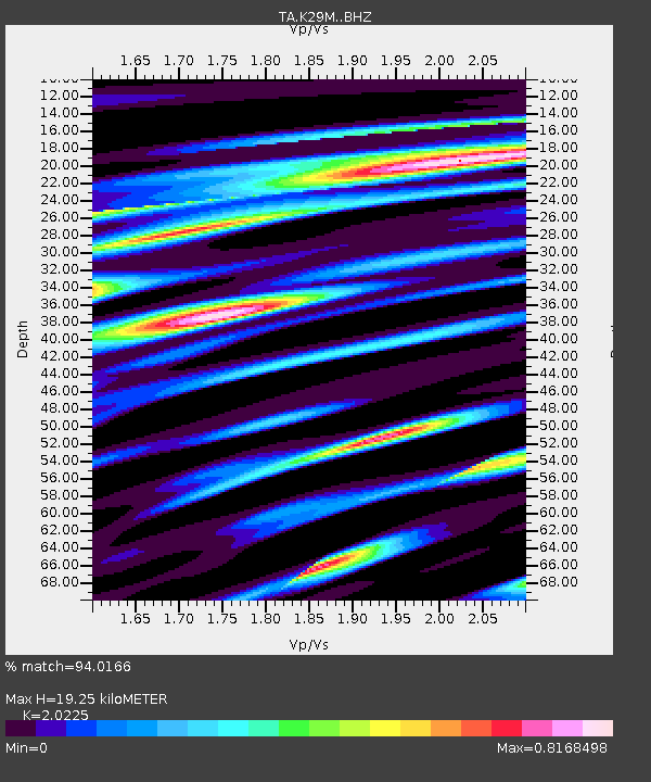
| Estimated Moho Depth: |
19.25 km |
| Estimated Crust Vp/Vs: |
2.02 |
| Assumed Crust Vp: |
6.566 km/s |
| Estimated Crust Vs: |
3.247 km/s |
| Estimated Crust Poisson's Ratio: |
0.34 |
|
| Radial Match: |
94.0166 % |
| Radial Bump: |
318 |
| Transverse Match: |
74.96114 % |
| Transverse Bump: |
400 |
| SOD ConfigId: |
13570011 |
| Insert Time: |
2019-05-01 18:39:13.626 +0000 |
| GWidth: |
2.5 |
| Max Bumps: |
400 |
| Tol: |
0.001 |
|

Signal To Noise
| Channel | StoN | STA | LTA |
| TA:K29M: :BHZ:20181109T01:56:43.325Z | 15.085545 | 2.890209E-6 | 1.9158799E-7 |
| TA:K29M: :BHN:20181109T01:56:43.325Z | 20.673927 | 2.1295707E-6 | 1.0300755E-7 |
| TA:K29M: :BHE:20181109T01:56:43.325Z | 4.9151497 | 7.9527683E-7 | 1.6180114E-7 |
| Arrivals |
| Ps | 3.2 SECOND |
| PpPs | 8.3 SECOND |
| PsPs/PpSs | 12 SECOND |


