You are here: Home > Network List > TA - USArray Transportable Network (new EarthScope stations) Stations List
> Station L26K Log Cabin Wilderness Lodge, Tok, AK, USA > Earthquake Result Viewer
L26K Log Cabin Wilderness Lodge, Tok, AK, USA - Earthquake Result Viewer
| Earthquake location: |
Jan Mayen Island Region |
| Earthquake latitude/longitude: |
71.6/-11.2 |
| Earthquake time(UTC): |
2018/11/09 (313) 01:49:40 GMT |
| Earthquake Depth: |
10 km |
| Earthquake Magnitude: |
6.8 Mww |
| Earthquake Catalog/Contributor: |
NEIC PDE/us |
|
| Network: |
TA USArray Transportable Network (new EarthScope stations) |
| Station: |
L26K Log Cabin Wilderness Lodge, Tok, AK, USA |
| Lat/Lon: |
63.03 N/143.35 W |
| Elevation: |
650 m |
|
| Distance: |
41.7 deg |
| Az: |
329.409 deg |
| Baz: |
20.73 deg |
| Ray Param: |
0.07364816 |
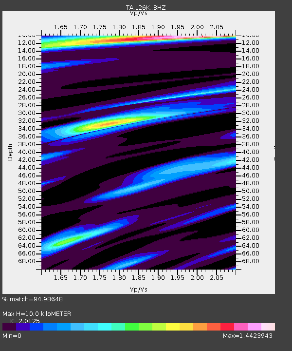
| Estimated Moho Depth: |
10.0 km |
| Estimated Crust Vp/Vs: |
2.01 |
| Assumed Crust Vp: |
6.566 km/s |
| Estimated Crust Vs: |
3.263 km/s |
| Estimated Crust Poisson's Ratio: |
0.34 |
|
| Radial Match: |
94.98648 % |
| Radial Bump: |
400 |
| Transverse Match: |
73.640465 % |
| Transverse Bump: |
400 |
| SOD ConfigId: |
13570011 |
| Insert Time: |
2019-05-01 18:39:19.451 +0000 |
| GWidth: |
2.5 |
| Max Bumps: |
400 |
| Tol: |
0.001 |
|

Signal To Noise
| Channel | StoN | STA | LTA |
| TA:L26K: :BHZ:20181109T01:56:57.700Z | 13.702471 | 1.8326454E-6 | 1.3374562E-7 |
| TA:L26K: :BHN:20181109T01:56:57.700Z | 3.7419758 | 1.0236939E-6 | 2.735704E-7 |
| TA:L26K: :BHE:20181109T01:56:57.700Z | 1.8122176 | 3.7461024E-7 | 2.0671372E-7 |
| Arrivals |
| Ps | 1.6 SECOND |
| PpPs | 4.3 SECOND |
| PsPs/PpSs | 6.0 SECOND |


