You are here: Home > Network List > TA - USArray Transportable Network (new EarthScope stations) Stations List
> Station G04A Mulino, OR, USA > Earthquake Result Viewer
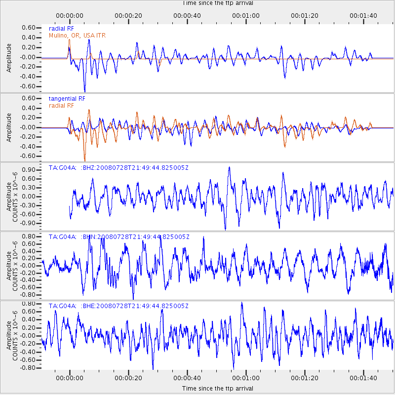
G04A Mulino, OR, USA - Earthquake Result Viewer
*The percent match for this event was below the threshold and hence no stack was calculated.
| Earthquake location: |
Solomon Islands |
| Earthquake latitude/longitude: |
-10.6/163.2 |
| Earthquake time(UTC): |
2008/07/28 (210) 21:37:32 GMT |
| Earthquake Depth: |
10 km |
| Earthquake Magnitude: |
5.7 MB, 6.1 MS, 5.9 MW |
| Earthquake Catalog/Contributor: |
WHDF/NEIC |
|
| Network: |
TA USArray Transportable Network (new EarthScope stations) |
| Station: |
G04A Mulino, OR, USA |
| Lat/Lon: |
45.21 N/122.48 W |
| Elevation: |
273 m |
|
| Distance: |
86.7 deg |
| Az: |
42.993 deg |
| Baz: |
251.502 deg |
| Ray Param: |
$rayparam |
*The percent match for this event was below the threshold and hence was not used in the summary stack. |
|
| Radial Match: |
60.481815 % |
| Radial Bump: |
400 |
| Transverse Match: |
49.602272 % |
| Transverse Bump: |
400 |
| SOD ConfigId: |
2658 |
| Insert Time: |
2010-03-06 17:42:25.019 +0000 |
| GWidth: |
2.5 |
| Max Bumps: |
400 |
| Tol: |
0.001 |
|
Signal To Noise
| Channel | StoN | STA | LTA |
| TA:G04A: :BHN:20080728T21:49:44.825005Z | 1.4562298 | 2.663305E-7 | 1.8289042E-7 |
| TA:G04A: :BHE:20080728T21:49:44.825005Z | 1.9352025 | 3.2021882E-7 | 1.6547044E-7 |
| TA:G04A: :BHZ:20080728T21:49:44.825005Z | 0.8293631 | 2.3884635E-7 | 2.879877E-7 |
| Arrivals |
| Ps | |
| PpPs | |
| PsPs/PpSs | |


