You are here: Home > Network List > TA - USArray Transportable Network (new EarthScope stations) Stations List
> Station P32M Atlin, BC, CAN > Earthquake Result Viewer
P32M Atlin, BC, CAN - Earthquake Result Viewer
| Earthquake location: |
Jan Mayen Island Region |
| Earthquake latitude/longitude: |
71.6/-11.2 |
| Earthquake time(UTC): |
2018/11/09 (313) 01:49:40 GMT |
| Earthquake Depth: |
10 km |
| Earthquake Magnitude: |
6.8 Mww |
| Earthquake Catalog/Contributor: |
NEIC PDE/us |
|
| Network: |
TA USArray Transportable Network (new EarthScope stations) |
| Station: |
P32M Atlin, BC, CAN |
| Lat/Lon: |
59.59 N/133.71 W |
| Elevation: |
793 m |
|
| Distance: |
43.1 deg |
| Az: |
321.113 deg |
| Baz: |
23.043 deg |
| Ray Param: |
0.07275232 |
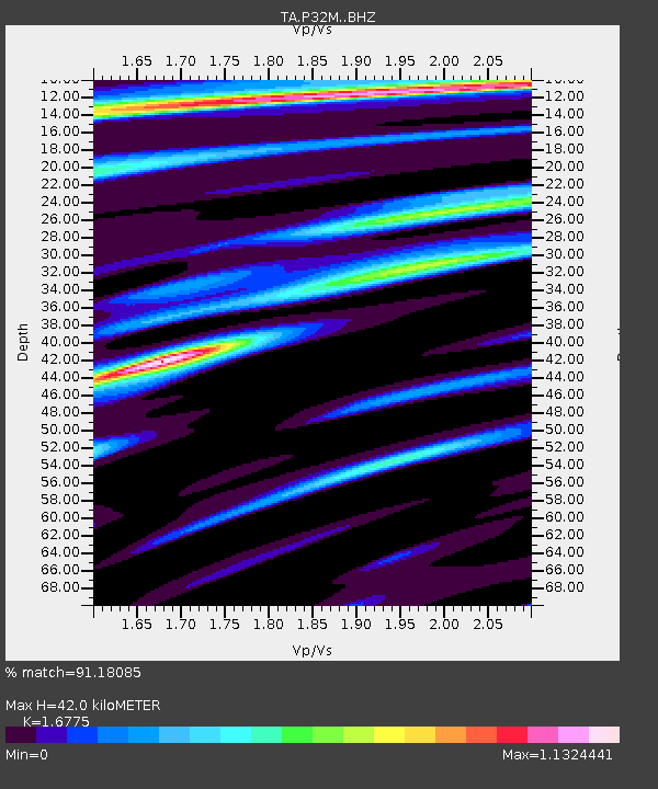
| Estimated Moho Depth: |
42.0 km |
| Estimated Crust Vp/Vs: |
1.68 |
| Assumed Crust Vp: |
6.597 km/s |
| Estimated Crust Vs: |
3.933 km/s |
| Estimated Crust Poisson's Ratio: |
0.22 |
|
| Radial Match: |
91.18085 % |
| Radial Bump: |
400 |
| Transverse Match: |
68.75748 % |
| Transverse Bump: |
400 |
| SOD ConfigId: |
13570011 |
| Insert Time: |
2019-05-01 18:39:58.296 +0000 |
| GWidth: |
2.5 |
| Max Bumps: |
400 |
| Tol: |
0.001 |
|

Signal To Noise
| Channel | StoN | STA | LTA |
| TA:P32M: :BHZ:20181109T01:57:09.575Z | 12.9149 | 1.6149517E-6 | 1.2504562E-7 |
| TA:P32M: :BHN:20181109T01:57:09.575Z | 5.9171953 | 9.0214564E-7 | 1.524617E-7 |
| TA:P32M: :BHE:20181109T01:57:09.575Z | 1.8080279 | 4.4900165E-7 | 2.4833778E-7 |
| Arrivals |
| Ps | 4.6 SECOND |
| PpPs | 16 SECOND |
| PsPs/PpSs | 20 SECOND |


