You are here: Home > Network List > TA - USArray Transportable Network (new EarthScope stations) Stations List
> Station Q32M Nakina River, BC, CAN > Earthquake Result Viewer
Q32M Nakina River, BC, CAN - Earthquake Result Viewer
| Earthquake location: |
Jan Mayen Island Region |
| Earthquake latitude/longitude: |
71.6/-11.2 |
| Earthquake time(UTC): |
2018/11/09 (313) 01:49:40 GMT |
| Earthquake Depth: |
10 km |
| Earthquake Magnitude: |
6.8 Mww |
| Earthquake Catalog/Contributor: |
NEIC PDE/us |
|
| Network: |
TA USArray Transportable Network (new EarthScope stations) |
| Station: |
Q32M Nakina River, BC, CAN |
| Lat/Lon: |
58.96 N/132.27 W |
| Elevation: |
1951 m |
|
| Distance: |
43.4 deg |
| Az: |
319.755 deg |
| Baz: |
23.295 deg |
| Ray Param: |
0.0725668 |
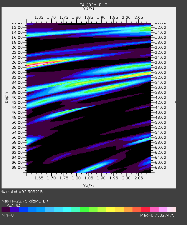
| Estimated Moho Depth: |
26.75 km |
| Estimated Crust Vp/Vs: |
1.64 |
| Assumed Crust Vp: |
6.597 km/s |
| Estimated Crust Vs: |
4.023 km/s |
| Estimated Crust Poisson's Ratio: |
0.20 |
|
| Radial Match: |
92.998215 % |
| Radial Bump: |
400 |
| Transverse Match: |
83.046196 % |
| Transverse Bump: |
400 |
| SOD ConfigId: |
13570011 |
| Insert Time: |
2019-05-01 18:40:03.906 +0000 |
| GWidth: |
2.5 |
| Max Bumps: |
400 |
| Tol: |
0.001 |
|

Signal To Noise
| Channel | StoN | STA | LTA |
| TA:Q32M: :BHZ:20181109T01:57:11.925006Z | 15.653472 | 2.9571795E-6 | 1.8891525E-7 |
| TA:Q32M: :BHN:20181109T01:57:11.925006Z | 8.391181 | 1.5822666E-6 | 1.8856304E-7 |
| TA:Q32M: :BHE:20181109T01:57:11.925006Z | 2.699717 | 5.8667587E-7 | 2.1731012E-7 |
| Arrivals |
| Ps | 2.8 SECOND |
| PpPs | 9.9 SECOND |
| PsPs/PpSs | 13 SECOND |


