You are here: Home > Network List > TA - USArray Transportable Network (new EarthScope stations) Stations List
> Station T35M Bob Quinn, BC, CAN > Earthquake Result Viewer
T35M Bob Quinn, BC, CAN - Earthquake Result Viewer

| Earthquake location: |
Jan Mayen Island Region |
| Earthquake latitude/longitude: |
71.6/-11.2 |
| Earthquake time(UTC): |
2018/11/09 (313) 01:49:40 GMT |
| Earthquake Depth: |
10 km |
| Earthquake Magnitude: |
6.8 Mww |
| Earthquake Catalog/Contributor: |
NEIC PDE/us |
|
| Network: |
TA USArray Transportable Network (new EarthScope stations) |
| Station: |
T35M Bob Quinn, BC, CAN |
| Lat/Lon: |
56.98 N/130.25 W |
| Elevation: |
609 m |
|
| Distance: |
44.8 deg |
| Az: |
317.209 deg |
| Baz: |
23.176 deg |
| Ray Param: |
0.071684495 |
| Estimated Moho Depth: |
40.25 km |
| Estimated Crust Vp/Vs: |
1.63 |
| Assumed Crust Vp: |
6.597 km/s |
| Estimated Crust Vs: |
4.048 km/s |
| Estimated Crust Poisson's Ratio: |
0.20 |
|
| Radial Match: |
89.04912 % |
| Radial Bump: |
400 |
| Transverse Match: |
69.18226 % |
| Transverse Bump: |
400 |
| SOD ConfigId: |
13570011 |
| Insert Time: |
2019-05-01 18:40:11.785 +0000 |
| GWidth: |
2.5 |
| Max Bumps: |
400 |
| Tol: |
0.001 |
|
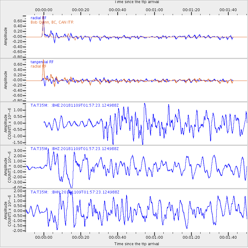
Signal To Noise
| Channel | StoN | STA | LTA |
| TA:T35M: :BHZ:20181109T01:57:23.124988Z | 6.426593 | 1.2308938E-6 | 1.9153131E-7 |
| TA:T35M: :BHN:20181109T01:57:23.124988Z | 2.9943547 | 5.659984E-7 | 1.8902183E-7 |
| TA:T35M: :BHE:20181109T01:57:23.124988Z | 2.2320437 | 5.201837E-7 | 2.3305263E-7 |
| Arrivals |
| Ps | 4.1 SECOND |
| PpPs | 15 SECOND |
| PsPs/PpSs | 19 SECOND |


