You are here: Home > Network List > TA - USArray Transportable Network (new EarthScope stations) Stations List
> Station G04A Mulino, OR, USA > Earthquake Result Viewer
G04A Mulino, OR, USA - Earthquake Result Viewer
*The percent match for this event was below the threshold and hence no stack was calculated.
| Earthquake location: |
Sichuan, China |
| Earthquake latitude/longitude: |
32.2/105.0 |
| Earthquake time(UTC): |
2008/05/17 (138) 17:08:25 GMT |
| Earthquake Depth: |
9.0 km |
| Earthquake Magnitude: |
5.8 MB, 5.6 MS, 5.7 MW, 5.7 MW |
| Earthquake Catalog/Contributor: |
WHDF/NEIC |
|
| Network: |
TA USArray Transportable Network (new EarthScope stations) |
| Station: |
G04A Mulino, OR, USA |
| Lat/Lon: |
45.21 N/122.48 W |
| Elevation: |
273 m |
|
| Distance: |
91.7 deg |
| Az: |
31.407 deg |
| Baz: |
321.342 deg |
| Ray Param: |
$rayparam |
*The percent match for this event was below the threshold and hence was not used in the summary stack. |
|
| Radial Match: |
64.903366 % |
| Radial Bump: |
400 |
| Transverse Match: |
69.86297 % |
| Transverse Bump: |
400 |
| SOD ConfigId: |
2504 |
| Insert Time: |
2010-03-06 17:42:47.361 +0000 |
| GWidth: |
2.5 |
| Max Bumps: |
400 |
| Tol: |
0.001 |
|
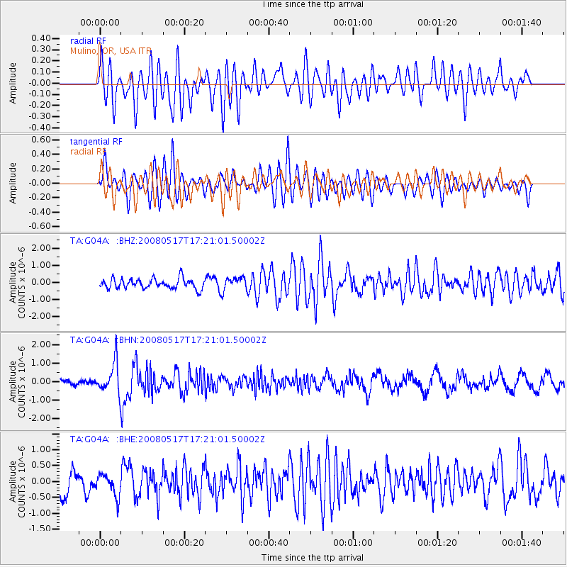
Signal To Noise
| Channel | StoN | STA | LTA |
| TA:G04A: :BHN:20080517T17:21:01.50002Z | 5.960188 | 8.578103E-7 | 1.4392336E-7 |
| TA:G04A: :BHE:20080517T17:21:01.50002Z | 1.1721483 | 3.5781832E-7 | 3.052671E-7 |
| TA:G04A: :BHZ:20080517T17:21:01.50002Z | 1.2739687 | 3.7491301E-7 | 2.9428745E-7 |
| Arrivals |
| Ps | |
| PpPs | |
| PsPs/PpSs | |


