You are here: Home > Network List > UO - University of Oregon Regional Network Stations List
> Station DRAN Drain, OR, USA > Earthquake Result Viewer
DRAN Drain, OR, USA - Earthquake Result Viewer
| Earthquake location: |
Jan Mayen Island Region |
| Earthquake latitude/longitude: |
71.6/-11.2 |
| Earthquake time(UTC): |
2018/11/09 (313) 01:49:40 GMT |
| Earthquake Depth: |
10 km |
| Earthquake Magnitude: |
6.8 Mww |
| Earthquake Catalog/Contributor: |
NEIC PDE/us |
|
| Network: |
UO University of Oregon Regional Network |
| Station: |
DRAN Drain, OR, USA |
| Lat/Lon: |
43.70 N/123.35 W |
| Elevation: |
141 m |
|
| Distance: |
55.5 deg |
| Az: |
305.383 deg |
| Baz: |
20.888 deg |
| Ray Param: |
0.064747274 |
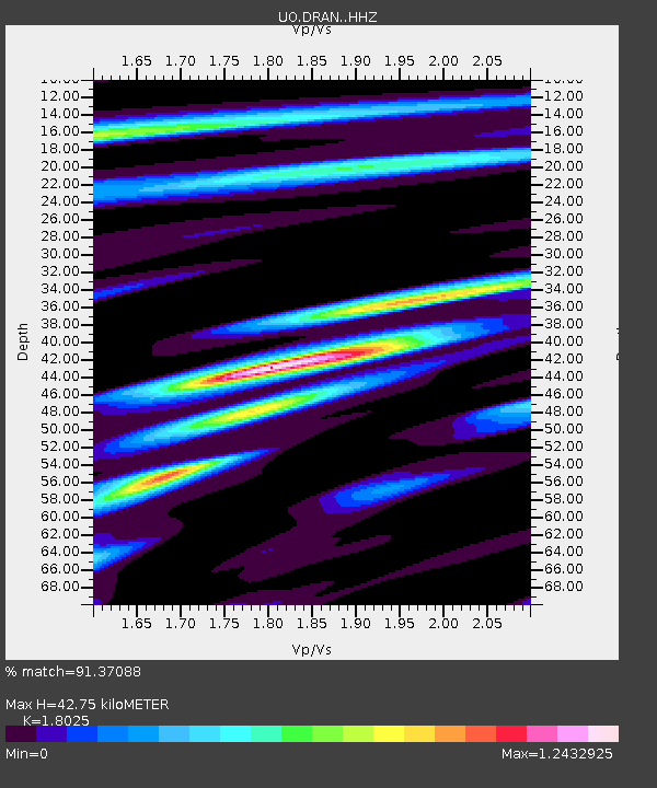
| Estimated Moho Depth: |
42.75 km |
| Estimated Crust Vp/Vs: |
1.80 |
| Assumed Crust Vp: |
6.522 km/s |
| Estimated Crust Vs: |
3.618 km/s |
| Estimated Crust Poisson's Ratio: |
0.28 |
|
| Radial Match: |
91.37088 % |
| Radial Bump: |
400 |
| Transverse Match: |
85.814316 % |
| Transverse Bump: |
400 |
| SOD ConfigId: |
13570011 |
| Insert Time: |
2019-05-01 18:41:07.149 +0000 |
| GWidth: |
2.5 |
| Max Bumps: |
400 |
| Tol: |
0.001 |
|

Signal To Noise
| Channel | StoN | STA | LTA |
| UO:DRAN: :HHZ:20181109T01:58:44.057971Z | 14.4932575 | 1.7890934E-6 | 1.2344316E-7 |
| UO:DRAN: :HHN:20181109T01:58:44.057971Z | 4.3756247 | 6.452209E-7 | 1.47458E-7 |
| UO:DRAN: :HHE:20181109T01:58:44.057971Z | 2.654403 | 3.7969238E-7 | 1.4304248E-7 |
| Arrivals |
| Ps | 5.5 SECOND |
| PpPs | 17 SECOND |
| PsPs/PpSs | 23 SECOND |


