You are here: Home > Network List > UW - Pacific Northwest Regional Seismic Network Stations List
> Station GNW Green Mountain (BB) > Earthquake Result Viewer
GNW Green Mountain (BB) - Earthquake Result Viewer
| Earthquake location: |
Jan Mayen Island Region |
| Earthquake latitude/longitude: |
71.6/-11.2 |
| Earthquake time(UTC): |
2018/11/09 (313) 01:49:40 GMT |
| Earthquake Depth: |
10 km |
| Earthquake Magnitude: |
6.8 Mww |
| Earthquake Catalog/Contributor: |
NEIC PDE/us |
|
| Network: |
UW Pacific Northwest Regional Seismic Network |
| Station: |
GNW Green Mountain (BB) |
| Lat/Lon: |
47.56 N/122.83 W |
| Elevation: |
160 m |
|
| Distance: |
51.8 deg |
| Az: |
306.716 deg |
| Baz: |
22.052 deg |
| Ray Param: |
0.06719277 |
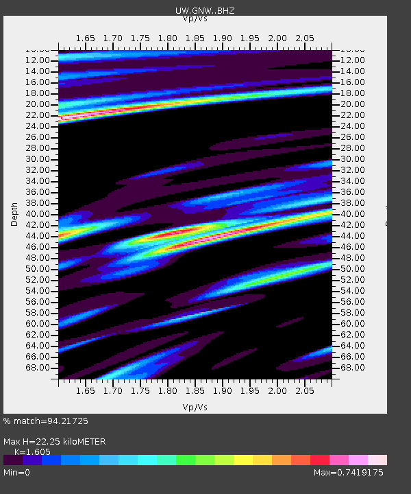
| Estimated Moho Depth: |
22.25 km |
| Estimated Crust Vp/Vs: |
1.61 |
| Assumed Crust Vp: |
6.566 km/s |
| Estimated Crust Vs: |
4.091 km/s |
| Estimated Crust Poisson's Ratio: |
0.18 |
|
| Radial Match: |
94.21725 % |
| Radial Bump: |
400 |
| Transverse Match: |
78.42875 % |
| Transverse Bump: |
400 |
| SOD ConfigId: |
13570011 |
| Insert Time: |
2019-05-01 18:41:41.335 +0000 |
| GWidth: |
2.5 |
| Max Bumps: |
400 |
| Tol: |
0.001 |
|

Signal To Noise
| Channel | StoN | STA | LTA |
| UW:GNW: :BHZ:20181109T01:58:16.749988Z | 9.715255 | 1.172008E-6 | 1.2063585E-7 |
| UW:GNW: :BHN:20181109T01:58:16.749988Z | 8.149237 | 6.075931E-7 | 7.455828E-8 |
| UW:GNW: :BHE:20181109T01:58:16.749988Z | 1.9343708 | 1.9586459E-7 | 1.0125493E-7 |
| Arrivals |
| Ps | 2.2 SECOND |
| PpPs | 8.3 SECOND |
| PsPs/PpSs | 10 SECOND |


