You are here: Home > Network List > TA - USArray Transportable Network (new EarthScope stations) Stations List
> Station G04A Mulino, OR, USA > Earthquake Result Viewer
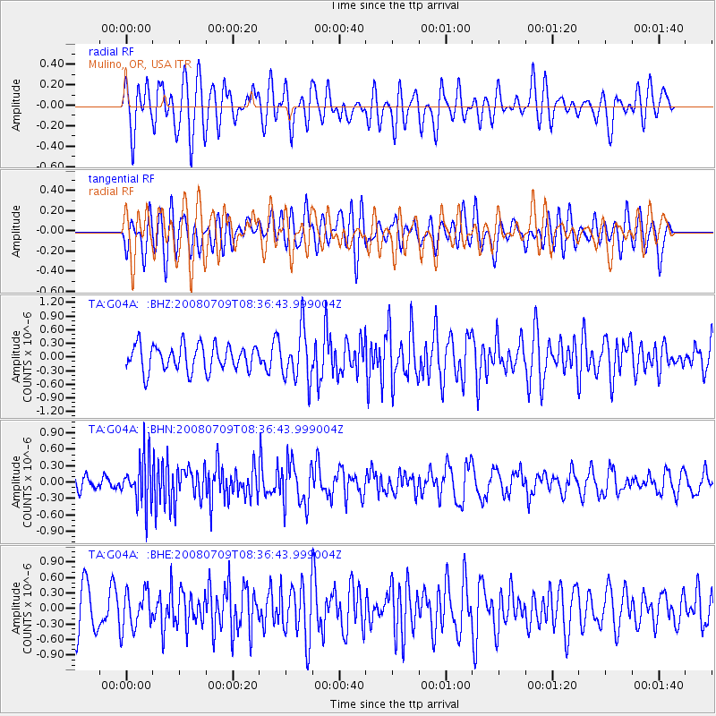
G04A Mulino, OR, USA - Earthquake Result Viewer
*The percent match for this event was below the threshold and hence no stack was calculated.
| Earthquake location: |
Loyalty Islands |
| Earthquake latitude/longitude: |
-20.9/168.8 |
| Earthquake time(UTC): |
2008/07/09 (191) 08:24:16 GMT |
| Earthquake Depth: |
39 km |
| Earthquake Magnitude: |
5.6 MB, 4.9 MS, 5.4 MW |
| Earthquake Catalog/Contributor: |
WHDF/NEIC |
|
| Network: |
TA USArray Transportable Network (new EarthScope stations) |
| Station: |
G04A Mulino, OR, USA |
| Lat/Lon: |
45.21 N/122.48 W |
| Elevation: |
273 m |
|
| Distance: |
90.7 deg |
| Az: |
41.218 deg |
| Baz: |
240.621 deg |
| Ray Param: |
$rayparam |
*The percent match for this event was below the threshold and hence was not used in the summary stack. |
|
| Radial Match: |
55.73749 % |
| Radial Bump: |
400 |
| Transverse Match: |
48.188393 % |
| Transverse Bump: |
400 |
| SOD ConfigId: |
2504 |
| Insert Time: |
2010-03-06 17:43:15.897 +0000 |
| GWidth: |
2.5 |
| Max Bumps: |
400 |
| Tol: |
0.001 |
|
Signal To Noise
| Channel | StoN | STA | LTA |
| TA:G04A: :BHN:20080709T08:36:43.999004Z | 1.8902875 | 4.2792152E-7 | 2.2637907E-7 |
| TA:G04A: :BHE:20080709T08:36:43.999004Z | 0.88798517 | 3.6846615E-7 | 4.149463E-7 |
| TA:G04A: :BHZ:20080709T08:36:43.999004Z | 1.9944799 | 5.641862E-7 | 2.8287386E-7 |
| Arrivals |
| Ps | |
| PpPs | |
| PsPs/PpSs | |


