You are here: Home > Network List > XU16 - USGS NEHRP Proposal 2016-2018 - Greeley, CO Stations List
> Station KE01 Kersey, CO, USA > Earthquake Result Viewer
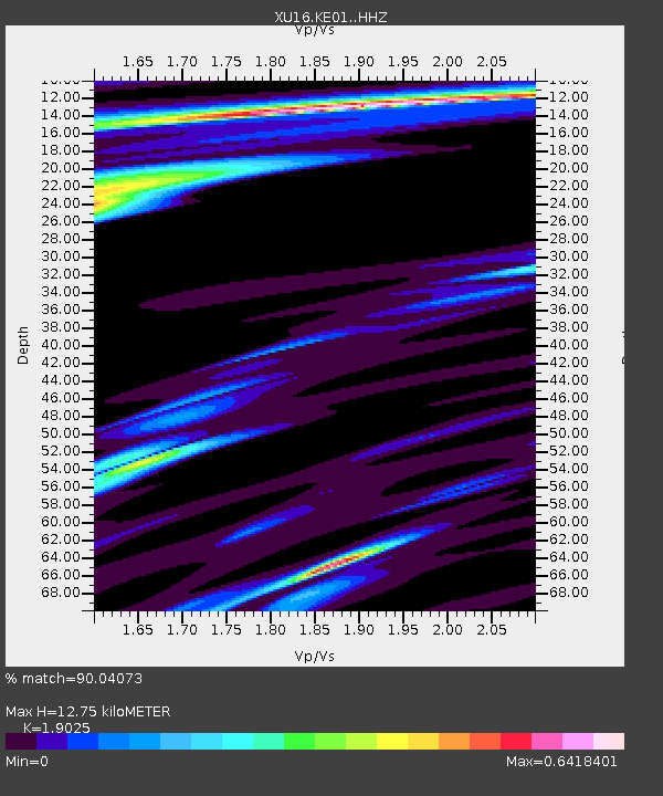
KE01 Kersey, CO, USA - Earthquake Result Viewer
| Earthquake location: |
Jan Mayen Island Region |
| Earthquake latitude/longitude: |
71.6/-11.2 |
| Earthquake time(UTC): |
2018/11/09 (313) 01:49:40 GMT |
| Earthquake Depth: |
10 km |
| Earthquake Magnitude: |
6.8 Mww |
| Earthquake Catalog/Contributor: |
NEIC PDE/us |
|
| Network: |
XU USGS NEHRP Proposal 2016-2018 - Greeley, CO |
| Station: |
KE01 Kersey, CO, USA |
| Lat/Lon: |
40.33 N/104.58 W |
| Elevation: |
1475 m |
|
| Distance: |
53.3 deg |
| Az: |
287.915 deg |
| Baz: |
23.251 deg |
| Ray Param: |
0.06617097 |
| Estimated Moho Depth: |
12.75 km |
| Estimated Crust Vp/Vs: |
1.90 |
| Assumed Crust Vp: |
6.306 km/s |
| Estimated Crust Vs: |
3.315 km/s |
| Estimated Crust Poisson's Ratio: |
0.31 |
|
| Radial Match: |
90.04073 % |
| Radial Bump: |
400 |
| Transverse Match: |
65.88557 % |
| Transverse Bump: |
400 |
| SOD ConfigId: |
13570011 |
| Insert Time: |
2019-05-01 18:42:36.469 +0000 |
| GWidth: |
2.5 |
| Max Bumps: |
400 |
| Tol: |
0.001 |
|

Signal To Noise
| Channel | StoN | STA | LTA |
| XU:KE01: :HHZ:20181109T01:58:28.26897Z | 3.3769848 | 1.1380488E-6 | 3.3700147E-7 |
| XU:KE01: :HH1:20181109T01:58:28.26897Z | 0.9999952 | 3.417364E-7 | 3.417381E-7 |
| XU:KE01: :HH2:20181109T01:58:28.26897Z | 1.3786695 | 3.0329406E-7 | 2.199904E-7 |
| Arrivals |
| Ps | 1.9 SECOND |
| PpPs | 5.6 SECOND |
| PsPs/PpSs | 7.5 SECOND |


