You are here: Home > Network List > TA - USArray Transportable Network (new EarthScope stations) Stations List
> Station G04A Mulino, OR, USA > Earthquake Result Viewer
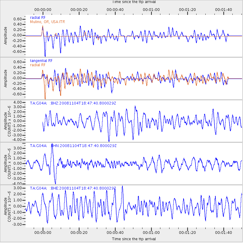
G04A Mulino, OR, USA - Earthquake Result Viewer
*The percent match for this event was below the threshold and hence no stack was calculated.
| Earthquake location: |
Vanuatu Islands |
| Earthquake latitude/longitude: |
-17.1/168.5 |
| Earthquake time(UTC): |
2008/11/04 (309) 18:35:45 GMT |
| Earthquake Depth: |
206 km |
| Earthquake Magnitude: |
5.7 MB, 6.3 MW, 6.3 MW |
| Earthquake Catalog/Contributor: |
WHDF/NEIC |
|
| Network: |
TA USArray Transportable Network (new EarthScope stations) |
| Station: |
G04A Mulino, OR, USA |
| Lat/Lon: |
45.21 N/122.48 W |
| Elevation: |
273 m |
|
| Distance: |
88.0 deg |
| Az: |
41.35 deg |
| Baz: |
243.325 deg |
| Ray Param: |
$rayparam |
*The percent match for this event was below the threshold and hence was not used in the summary stack. |
|
| Radial Match: |
64.12994 % |
| Radial Bump: |
400 |
| Transverse Match: |
63.61844 % |
| Transverse Bump: |
400 |
| SOD ConfigId: |
2658 |
| Insert Time: |
2010-03-06 17:43:34.306 +0000 |
| GWidth: |
2.5 |
| Max Bumps: |
400 |
| Tol: |
0.001 |
|
Signal To Noise
| Channel | StoN | STA | LTA |
| TA:G04A: :BHN:20081104T18:47:40.800029Z | 2.184165 | 1.2557825E-6 | 5.7494856E-7 |
| TA:G04A: :BHE:20081104T18:47:40.800029Z | 1.7753532 | 1.404702E-6 | 7.91224E-7 |
| TA:G04A: :BHZ:20081104T18:47:40.800029Z | 1.6893549 | 1.4731934E-6 | 8.720449E-7 |
| Arrivals |
| Ps | |
| PpPs | |
| PsPs/PpSs | |


