You are here: Home > Network List > TA - USArray Transportable Network (new EarthScope stations) Stations List
> Station G04A Mulino, OR, USA > Earthquake Result Viewer
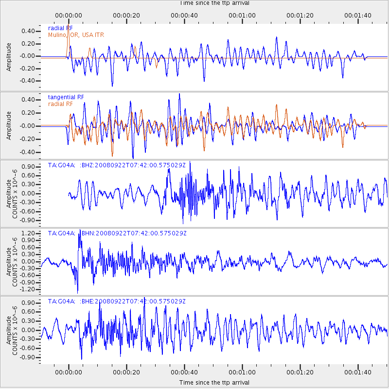
G04A Mulino, OR, USA - Earthquake Result Viewer
*The percent match for this event was below the threshold and hence no stack was calculated.
| Earthquake location: |
Hokkaido, Japan Region |
| Earthquake latitude/longitude: |
41.6/140.4 |
| Earthquake time(UTC): |
2008/09/22 (266) 07:31:59 GMT |
| Earthquake Depth: |
149 km |
| Earthquake Magnitude: |
5.7 MW, 5.3 MB, 5.6 MW |
| Earthquake Catalog/Contributor: |
WHDF/NEIC |
|
| Network: |
TA USArray Transportable Network (new EarthScope stations) |
| Station: |
G04A Mulino, OR, USA |
| Lat/Lon: |
45.21 N/122.48 W |
| Elevation: |
273 m |
|
| Distance: |
66.3 deg |
| Az: |
50.024 deg |
| Baz: |
305.583 deg |
| Ray Param: |
$rayparam |
*The percent match for this event was below the threshold and hence was not used in the summary stack. |
|
| Radial Match: |
57.061577 % |
| Radial Bump: |
400 |
| Transverse Match: |
66.31269 % |
| Transverse Bump: |
400 |
| SOD ConfigId: |
2560 |
| Insert Time: |
2010-03-06 17:43:38.029 +0000 |
| GWidth: |
2.5 |
| Max Bumps: |
400 |
| Tol: |
0.001 |
|
Signal To Noise
| Channel | StoN | STA | LTA |
| TA:G04A: :BHN:20080922T07:42:00.575029Z | 3.6342845 | 5.7879816E-7 | 1.5926055E-7 |
| TA:G04A: :BHE:20080922T07:42:00.575029Z | 1.7161472 | 2.848454E-7 | 1.6597959E-7 |
| TA:G04A: :BHZ:20080922T07:42:00.575029Z | 1.7683605 | 3.872313E-7 | 2.1897758E-7 |
| Arrivals |
| Ps | |
| PpPs | |
| PsPs/PpSs | |


