You are here: Home > Network List > TA - USArray Transportable Network (new EarthScope stations) Stations List
> Station Z14A Wintersburg, AZ, USA > Earthquake Result Viewer
Z14A Wintersburg, AZ, USA - Earthquake Result Viewer

| Earthquake location: |
Fiji Islands Region |
| Earthquake latitude/longitude: |
-17.3/-177.3 |
| Earthquake time(UTC): |
2008/07/19 (201) 22:39:52 GMT |
| Earthquake Depth: |
391 km |
| Earthquake Magnitude: |
5.9 MB, 6.4 MW, 6.4 MW |
| Earthquake Catalog/Contributor: |
WHDF/NEIC |
|
| Network: |
TA USArray Transportable Network (new EarthScope stations) |
| Station: |
Z14A Wintersburg, AZ, USA |
| Lat/Lon: |
33.36 N/112.95 W |
| Elevation: |
298 m |
|
| Distance: |
79.4 deg |
| Az: |
50.138 deg |
| Baz: |
241.168 deg |
| Ray Param: |
0.0478934 |
| Estimated Moho Depth: |
27.25 km |
| Estimated Crust Vp/Vs: |
1.79 |
| Assumed Crust Vp: |
6.264 km/s |
| Estimated Crust Vs: |
3.499 km/s |
| Estimated Crust Poisson's Ratio: |
0.27 |
|
| Radial Match: |
92.34067 % |
| Radial Bump: |
400 |
| Transverse Match: |
79.038055 % |
| Transverse Bump: |
400 |
| SOD ConfigId: |
2504 |
| Insert Time: |
2010-03-06 17:43:55.095 +0000 |
| GWidth: |
2.5 |
| Max Bumps: |
400 |
| Tol: |
0.001 |
|
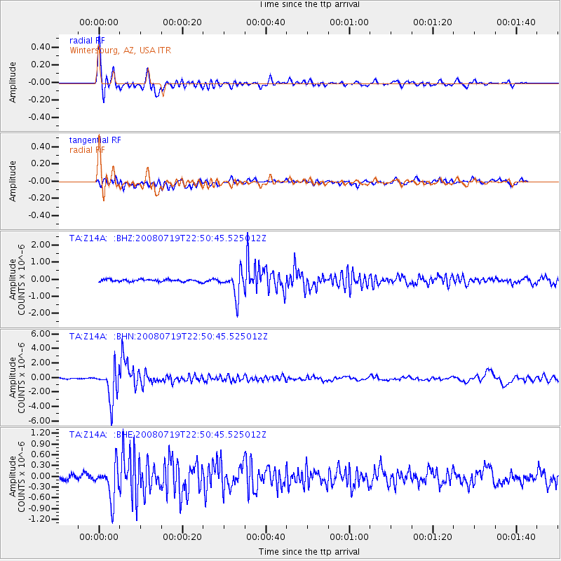
Signal To Noise
| Channel | StoN | STA | LTA |
| TA:Z14A: :BHN:20080719T22:50:45.525012Z | 30.068628 | 2.2378983E-6 | 7.442635E-8 |
| TA:Z14A: :BHE:20080719T22:50:45.525012Z | 5.5311084 | 4.899967E-7 | 8.858924E-8 |
| TA:Z14A: :BHZ:20080719T22:50:45.525012Z | 11.386158 | 7.328998E-7 | 6.436761E-8 |
| Arrivals |
| Ps | 3.5 SECOND |
| PpPs | 12 SECOND |
| PsPs/PpSs | 15 SECOND |


