You are here: Home > Network List > TA - USArray Transportable Network (new EarthScope stations) Stations List
> Station Z14A Wintersburg, AZ, USA > Earthquake Result Viewer
Z14A Wintersburg, AZ, USA - Earthquake Result Viewer

| Earthquake location: |
Southeast Of Loyalty Islands |
| Earthquake latitude/longitude: |
-21.2/169.2 |
| Earthquake time(UTC): |
2007/10/13 (286) 17:45:53 GMT |
| Earthquake Depth: |
37 km |
| Earthquake Magnitude: |
5.8 MB, 5.9 MS, 6.1 MW, 6.1 MW |
| Earthquake Catalog/Contributor: |
WHDF/NEIC |
|
| Network: |
TA USArray Transportable Network (new EarthScope stations) |
| Station: |
Z14A Wintersburg, AZ, USA |
| Lat/Lon: |
33.36 N/112.95 W |
| Elevation: |
298 m |
|
| Distance: |
91.9 deg |
| Az: |
54.947 deg |
| Baz: |
245.864 deg |
| Ray Param: |
0.04153228 |
| Estimated Moho Depth: |
25.75 km |
| Estimated Crust Vp/Vs: |
1.92 |
| Assumed Crust Vp: |
6.264 km/s |
| Estimated Crust Vs: |
3.267 km/s |
| Estimated Crust Poisson's Ratio: |
0.31 |
|
| Radial Match: |
80.568794 % |
| Radial Bump: |
400 |
| Transverse Match: |
56.621754 % |
| Transverse Bump: |
400 |
| SOD ConfigId: |
2564 |
| Insert Time: |
2010-03-06 17:44:32.198 +0000 |
| GWidth: |
2.5 |
| Max Bumps: |
400 |
| Tol: |
0.001 |
|
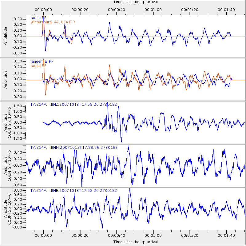
Signal To Noise
| Channel | StoN | STA | LTA |
| TA:Z14A: :BHN:20071013T17:58:26.273018Z | 0.6954457 | 1.17714436E-7 | 1.6926474E-7 |
| TA:Z14A: :BHE:20071013T17:58:26.273018Z | 1.2830228 | 1.0910548E-7 | 8.503783E-8 |
| TA:Z14A: :BHZ:20071013T17:58:26.273018Z | 3.8981154 | 4.1099412E-7 | 1.05434054E-7 |
| Arrivals |
| Ps | 3.8 SECOND |
| PpPs | 12 SECOND |
| PsPs/PpSs | 16 SECOND |


