You are here: Home > Network List > TA - USArray Transportable Network (new EarthScope stations) Stations List
> Station Z14A Wintersburg, AZ, USA > Earthquake Result Viewer
Z14A Wintersburg, AZ, USA - Earthquake Result Viewer
| Earthquake location: |
Near West Coast Of Colombia |
| Earthquake latitude/longitude: |
3.0/-78.0 |
| Earthquake time(UTC): |
2007/09/10 (253) 01:49:14 GMT |
| Earthquake Depth: |
31 km |
| Earthquake Magnitude: |
6.1 MB, 6.7 MS, 6.8 MW |
| Earthquake Catalog/Contributor: |
WHDF/NEIC |
|
| Network: |
TA USArray Transportable Network (new EarthScope stations) |
| Station: |
Z14A Wintersburg, AZ, USA |
| Lat/Lon: |
33.36 N/112.95 W |
| Elevation: |
298 m |
|
| Distance: |
44.5 deg |
| Az: |
316.816 deg |
| Baz: |
125.252 deg |
| Ray Param: |
0.07181248 |
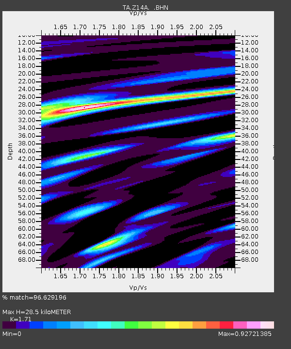
| Estimated Moho Depth: |
28.5 km |
| Estimated Crust Vp/Vs: |
1.71 |
| Assumed Crust Vp: |
6.264 km/s |
| Estimated Crust Vs: |
3.663 km/s |
| Estimated Crust Poisson's Ratio: |
0.24 |
|
| Radial Match: |
96.629196 % |
| Radial Bump: |
400 |
| Transverse Match: |
83.281845 % |
| Transverse Bump: |
400 |
| SOD ConfigId: |
2564 |
| Insert Time: |
2010-03-06 17:44:44.628 +0000 |
| GWidth: |
2.5 |
| Max Bumps: |
400 |
| Tol: |
0.001 |
|

Signal To Noise
| Channel | StoN | STA | LTA |
| TA:Z14A: :BHN:20070910T01:56:52.248015Z | 5.4698653 | 6.565124E-7 | 1.2002351E-7 |
| TA:Z14A: :BHE:20070910T01:56:52.248015Z | 6.568954 | 7.8126806E-7 | 1.1893341E-7 |
| TA:Z14A: :BHZ:20070910T01:56:52.248015Z | 14.156359 | 1.7695647E-6 | 1.250014E-7 |
| Arrivals |
| Ps | 3.4 SECOND |
| PpPs | 12 SECOND |
| PsPs/PpSs | 15 SECOND |


