You are here: Home > Network List > TA - USArray Transportable Network (new EarthScope stations) Stations List
> Station D25K Kavik River, AK, USA > Earthquake Result Viewer
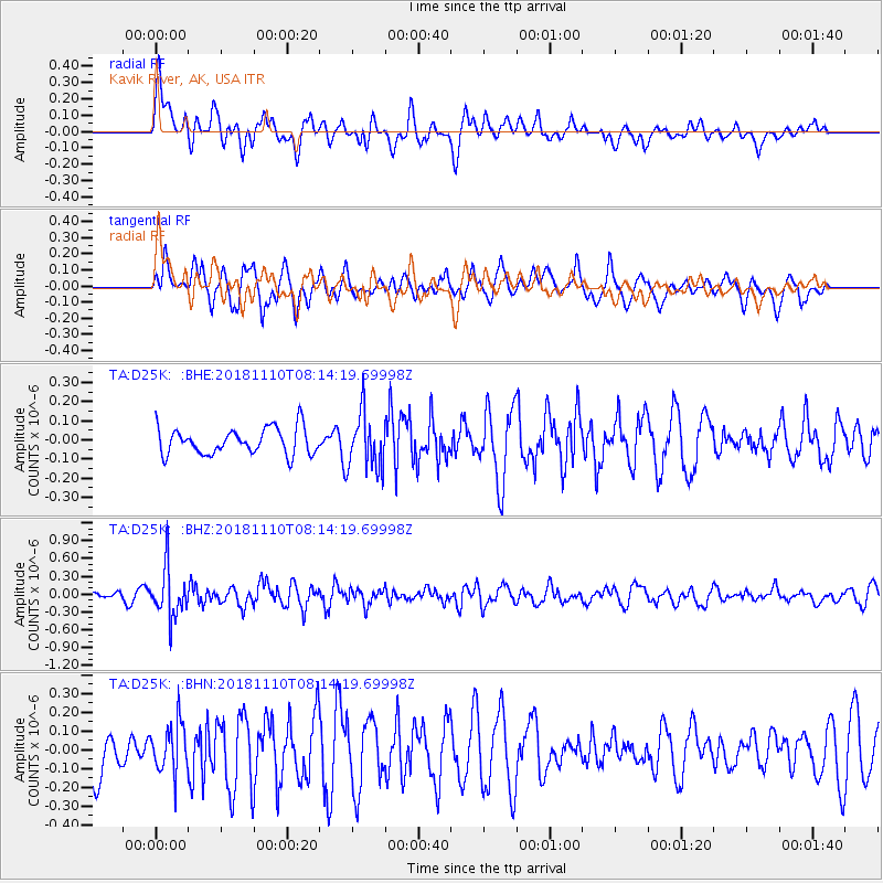
D25K Kavik River, AK, USA - Earthquake Result Viewer
*The percent match for this event was below the threshold and hence no stack was calculated.
| Earthquake location: |
New Britain Region, P.N.G. |
| Earthquake latitude/longitude: |
-5.8/151.7 |
| Earthquake time(UTC): |
2018/11/10 (314) 08:02:16 GMT |
| Earthquake Depth: |
52 km |
| Earthquake Magnitude: |
5.7 Mww |
| Earthquake Catalog/Contributor: |
NEIC PDE/us |
|
| Network: |
TA USArray Transportable Network (new EarthScope stations) |
| Station: |
D25K Kavik River, AK, USA |
| Lat/Lon: |
69.32 N/146.38 W |
| Elevation: |
770 m |
|
| Distance: |
85.8 deg |
| Az: |
18.31 deg |
| Baz: |
241.643 deg |
| Ray Param: |
$rayparam |
*The percent match for this event was below the threshold and hence was not used in the summary stack. |
|
| Radial Match: |
46.931248 % |
| Radial Bump: |
400 |
| Transverse Match: |
59.748116 % |
| Transverse Bump: |
400 |
| SOD ConfigId: |
13570011 |
| Insert Time: |
2019-05-01 18:56:52.442 +0000 |
| GWidth: |
2.5 |
| Max Bumps: |
400 |
| Tol: |
0.001 |
|
Signal To Noise
| Channel | StoN | STA | LTA |
| TA:D25K: :BHZ:20181110T08:14:19.69998Z | 4.679012 | 4.100252E-7 | 8.7630724E-8 |
| TA:D25K: :BHN:20181110T08:14:19.69998Z | 0.9021076 | 1.3167181E-7 | 1.459602E-7 |
| TA:D25K: :BHE:20181110T08:14:19.69998Z | 2.163877 | 1.4930737E-7 | 6.899993E-8 |
| Arrivals |
| Ps | |
| PpPs | |
| PsPs/PpSs | |


