You are here: Home > Network List > TS - TERRAscope (Southern California Seismic Network) Stations List
> Station BAR Barrett Dam, California, USA > Earthquake Result Viewer
BAR Barrett Dam, California, USA - Earthquake Result Viewer
*The percent match for this event was below the threshold and hence no stack was calculated.
| Earthquake location: |
Kermadec Islands Region |
| Earthquake latitude/longitude: |
-29.4/-176.7 |
| Earthquake time(UTC): |
1993/06/18 (169) 11:52:51 GMT |
| Earthquake Depth: |
21 km |
| Earthquake Magnitude: |
6.2 MB, 6.8 MS, 6.9 UNKNOWN, 6.8 MW |
| Earthquake Catalog/Contributor: |
WHDF/NEIC |
|
| Network: |
TS TERRAscope (Southern California Seismic Network) |
| Station: |
BAR Barrett Dam, California, USA |
| Lat/Lon: |
32.68 N/116.67 W |
| Elevation: |
548 m |
|
| Distance: |
84.0 deg |
| Az: |
47.3 deg |
| Baz: |
229.507 deg |
| Ray Param: |
$rayparam |
*The percent match for this event was below the threshold and hence was not used in the summary stack. |
|
| Radial Match: |
42.432278 % |
| Radial Bump: |
400 |
| Transverse Match: |
61.08506 % |
| Transverse Bump: |
400 |
| SOD ConfigId: |
4480 |
| Insert Time: |
2010-02-26 14:00:20.172 +0000 |
| GWidth: |
2.5 |
| Max Bumps: |
400 |
| Tol: |
0.001 |
|
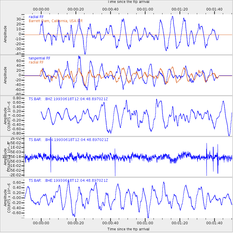
Signal To Noise
| Channel | StoN | STA | LTA |
| TS:BAR: :BHN:19930618T12:04:48.897021Z | 0.79201686 | 1.8413016E-9 | 2.324826E-9 |
| TS:BAR: :BHE:19930618T12:04:48.897021Z | 0.8230575 | 1.5393721E-7 | 1.8703093E-7 |
| TS:BAR: :BHZ:19930618T12:04:48.897021Z | 1.0173327 | 1.9303671E-7 | 1.8974788E-7 |
| Arrivals |
| Ps | |
| PpPs | |
| PsPs/PpSs | |


