You are here: Home > Network List > TA - USArray Transportable Network (new EarthScope stations) Stations List
> Station Z14A Wintersburg, AZ, USA > Earthquake Result Viewer
Z14A Wintersburg, AZ, USA - Earthquake Result Viewer

| Earthquake location: |
Tonga Islands |
| Earthquake latitude/longitude: |
-20.1/-174.5 |
| Earthquake time(UTC): |
2007/05/27 (147) 18:12:34 GMT |
| Earthquake Depth: |
7.3 km |
| Earthquake Magnitude: |
5.8 MB, 5.1 MS, 5.6 MW, 5.5 MW |
| Earthquake Catalog/Contributor: |
WHDF/NEIC |
|
| Network: |
TA USArray Transportable Network (new EarthScope stations) |
| Station: |
Z14A Wintersburg, AZ, USA |
| Lat/Lon: |
33.36 N/112.95 W |
| Elevation: |
298 m |
|
| Distance: |
79.2 deg |
| Az: |
48.531 deg |
| Baz: |
237.315 deg |
| Ray Param: |
0.04914485 |
| Estimated Moho Depth: |
27.25 km |
| Estimated Crust Vp/Vs: |
1.81 |
| Assumed Crust Vp: |
6.264 km/s |
| Estimated Crust Vs: |
3.461 km/s |
| Estimated Crust Poisson's Ratio: |
0.28 |
|
| Radial Match: |
88.68826 % |
| Radial Bump: |
400 |
| Transverse Match: |
67.25361 % |
| Transverse Bump: |
400 |
| SOD ConfigId: |
2564 |
| Insert Time: |
2010-03-06 17:45:39.474 +0000 |
| GWidth: |
2.5 |
| Max Bumps: |
400 |
| Tol: |
0.001 |
|
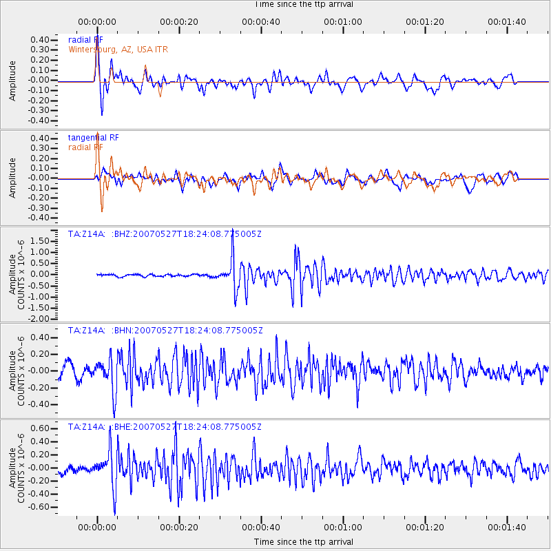
Signal To Noise
| Channel | StoN | STA | LTA |
| TA:Z14A: :BHN:20070527T18:24:08.775005Z | 2.534795 | 1.9817256E-7 | 7.81809E-8 |
| TA:Z14A: :BHE:20070527T18:24:08.775005Z | 5.7256465 | 2.814601E-7 | 4.9157784E-8 |
| TA:Z14A: :BHZ:20070527T18:24:08.775005Z | 14.293303 | 6.7980454E-7 | 4.7561052E-8 |
| Arrivals |
| Ps | 3.6 SECOND |
| PpPs | 12 SECOND |
| PsPs/PpSs | 16 SECOND |


