You are here: Home > Network List > TA - USArray Transportable Network (new EarthScope stations) Stations List
> Station Z14A Wintersburg, AZ, USA > Earthquake Result Viewer
Z14A Wintersburg, AZ, USA - Earthquake Result Viewer
| Earthquake location: |
Vanuatu Islands |
| Earthquake latitude/longitude: |
-20.6/169.4 |
| Earthquake time(UTC): |
2007/03/25 (084) 00:40:01 GMT |
| Earthquake Depth: |
34 km |
| Earthquake Magnitude: |
6.5 MB, 7.0 MS, 7.1 MW, 7.1 MW |
| Earthquake Catalog/Contributor: |
WHDF/NEIC |
|
| Network: |
TA USArray Transportable Network (new EarthScope stations) |
| Station: |
Z14A Wintersburg, AZ, USA |
| Lat/Lon: |
33.36 N/112.95 W |
| Elevation: |
298 m |
|
| Distance: |
91.4 deg |
| Az: |
54.878 deg |
| Baz: |
246.276 deg |
| Ray Param: |
0.04160008 |
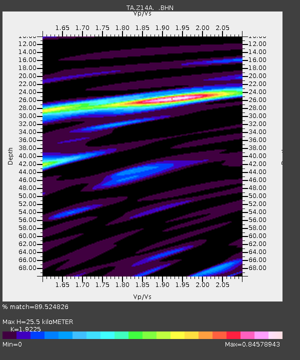
| Estimated Moho Depth: |
25.5 km |
| Estimated Crust Vp/Vs: |
1.92 |
| Assumed Crust Vp: |
6.264 km/s |
| Estimated Crust Vs: |
3.258 km/s |
| Estimated Crust Poisson's Ratio: |
0.31 |
|
| Radial Match: |
89.524826 % |
| Radial Bump: |
330 |
| Transverse Match: |
74.28273 % |
| Transverse Bump: |
400 |
| SOD ConfigId: |
2564 |
| Insert Time: |
2010-03-06 17:45:46.213 +0000 |
| GWidth: |
2.5 |
| Max Bumps: |
400 |
| Tol: |
0.001 |
|
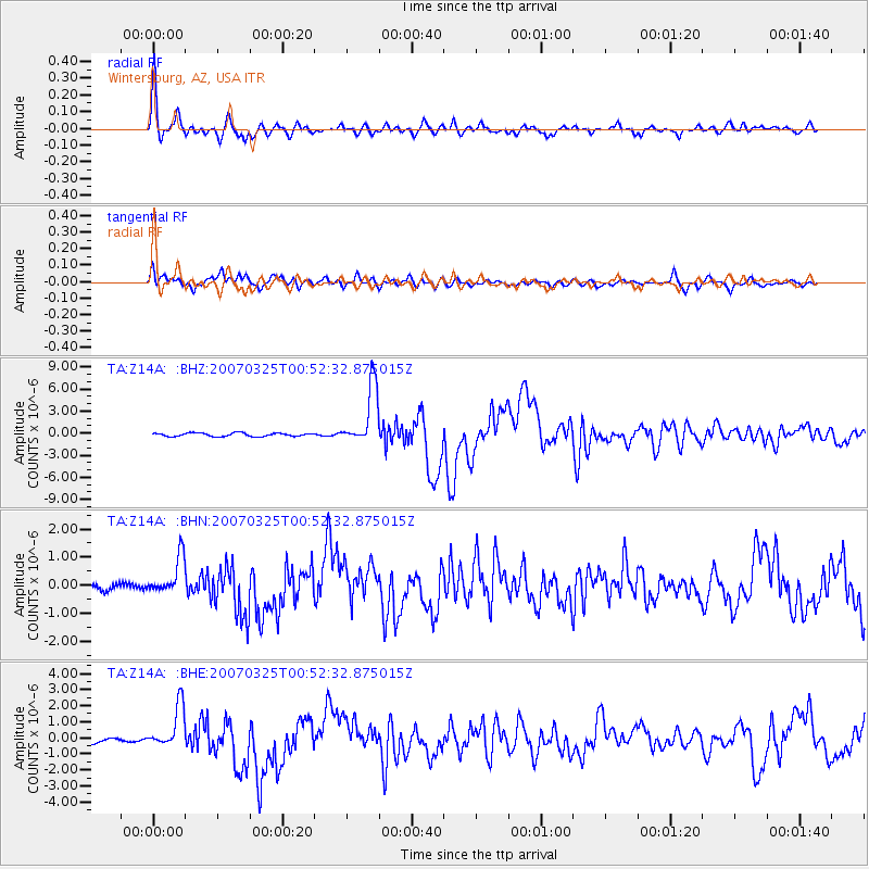
Signal To Noise
| Channel | StoN | STA | LTA |
| TA:Z14A: :BHN:20070325T00:52:32.875015Z | 3.9979846 | 6.656665E-7 | 1.6650053E-7 |
| TA:Z14A: :BHE:20070325T00:52:32.875015Z | 8.303567 | 1.3439234E-6 | 1.6184893E-7 |
| TA:Z14A: :BHZ:20070325T00:52:32.875015Z | 17.861164 | 4.040981E-6 | 2.2624397E-7 |
| Arrivals |
| Ps | 3.8 SECOND |
| PpPs | 12 SECOND |
| PsPs/PpSs | 16 SECOND |


