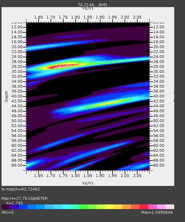
Z14A Wintersburg, AZ, USA - Earthquake Result Viewer
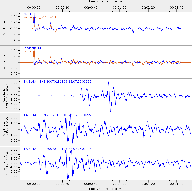
Earthquake location: Kermadec Islands, New Zealand
Earthquake latitude/longitude: -29.8/-178.0
Earthquake time(UTC): 2007/01/31 (031) 03:15:52 GMT
Earthquake Depth: 34 km
Earthquake Magnitude: 6.1 MB, 6.3 MS, 6.5 MW, 6.4 MW
Earthquake Catalog/Contributor: WHDF/NEIC
Network: TA USArray Transportable Network (new EarthScope stations)
Station: Z14A Wintersburg, AZ, USA
Lat/Lon: 33.36 N/112.95 W
Elevation: 298 m
Distance: 87.9 deg
Az: 49.406 deg
Baz: 232.076 deg
Ray Param: 0.042931437
Estimated Moho Depth: 27.75 km
Estimated Crust Vp/Vs: 1.75
Assumed Crust Vp: 6.264 km/s
Estimated Crust Vs: 3.589 km/s
Estimated Crust Poisson's Ratio: 0.26
Radial Match: 93.72482 %
Radial Bump: 327
Transverse Match: 78.56232 %
Transverse Bump: 400
SOD ConfigId: 2564
Insert Time: 2010-03-06 17:45:50.633 +0000
GWidth: 2.5
Max Bumps: 400
Tol: 0.001

Signal To Noise

ChannelStoNSTALTA
TA:Z14A: :BHN:20070131T03:28:07.250022Z1.65593425.665551E-73.4213625E-7
TA:Z14A: :BHE:20070131T03:28:07.250022Z2.34285076.225665E-72.6573034E-7
TA:Z14A: :BHZ:20070131T03:28:07.250022Z17.4097942.017154E-61.1586317E-7
Arrivals
Ps3.4 SECOND
PpPs12 SECOND
PsPs/PpSs15 SECOND