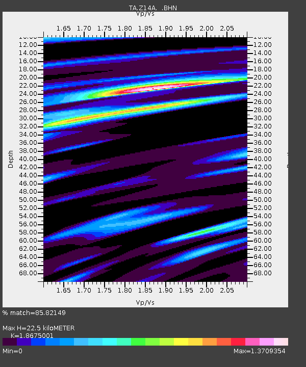
Z14A Wintersburg, AZ, USA - Earthquake Result Viewer
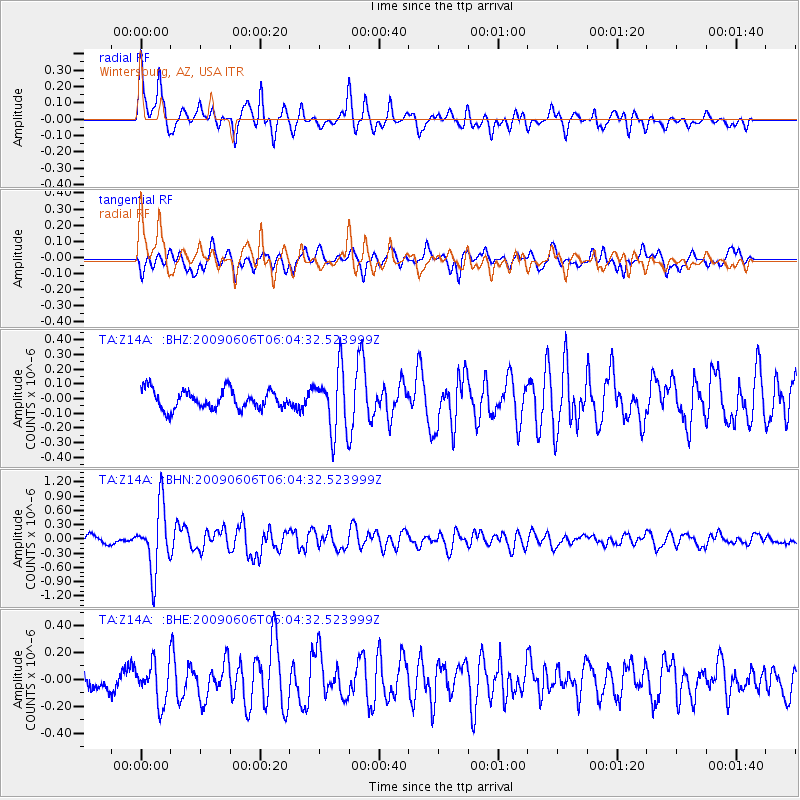
Earthquake location: Near East Coast Of Honshu, Japan
Earthquake latitude/longitude: 35.5/140.9
Earthquake time(UTC): 2009/06/06 (157) 05:52:43 GMT
Earthquake Depth: 34 km
Earthquake Magnitude: 5.8 MB, 5.4 MS, 5.8 MW, 5.7 MW
Earthquake Catalog/Contributor: WHDF/NEIC
Network: TA USArray Transportable Network (new EarthScope stations)
Station: Z14A Wintersburg, AZ, USA
Lat/Lon: 33.36 N/112.95 W
Elevation: 298 m
Distance: 82.7 deg
Az: 54.136 deg
Baz: 307.787 deg
Ray Param: 0.046634406
Estimated Moho Depth: 22.5 km
Estimated Crust Vp/Vs: 1.87
Assumed Crust Vp: 6.264 km/s
Estimated Crust Vs: 3.354 km/s
Estimated Crust Poisson's Ratio: 0.30
Radial Match: 85.82149 %
Radial Bump: 400
Transverse Match: 72.834984 %
Transverse Bump: 400
SOD ConfigId: 2648
Insert Time: 2010-03-06 17:46:41.598 +0000
GWidth: 2.5
Max Bumps: 400
Tol: 0.001

Signal To Noise

ChannelStoNSTALTA
TA:Z14A: :BHN:20090606T06:04:32.523999Z7.6973366.7970143E-78.830346E-8
TA:Z14A: :BHE:20090606T06:04:32.523999Z2.27647381.4818619E-76.509462E-8
TA:Z14A: :BHZ:20090606T06:04:32.523999Z3.2633692.0982624E-76.429743E-8
Arrivals
Ps3.2 SECOND
PpPs10 SECOND
PsPs/PpSs13 SECOND