You are here: Home > Network List > TA - USArray Transportable Network (new EarthScope stations) Stations List
> Station Z14A Wintersburg, AZ, USA > Earthquake Result Viewer
Z14A Wintersburg, AZ, USA - Earthquake Result Viewer
| Earthquake location: |
Costa Rica |
| Earthquake latitude/longitude: |
8.5/-83.2 |
| Earthquake time(UTC): |
2009/03/11 (070) 17:24:36 GMT |
| Earthquake Depth: |
14 km |
| Earthquake Magnitude: |
5.8 MB, 5.6 MS, 5.9 MW, 5.9 MW |
| Earthquake Catalog/Contributor: |
WHDF/NEIC |
|
| Network: |
TA USArray Transportable Network (new EarthScope stations) |
| Station: |
Z14A Wintersburg, AZ, USA |
| Lat/Lon: |
33.36 N/112.95 W |
| Elevation: |
298 m |
|
| Distance: |
36.9 deg |
| Az: |
316.326 deg |
| Baz: |
125.295 deg |
| Ray Param: |
0.07639862 |
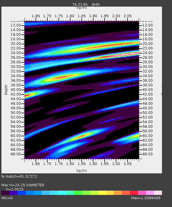
| Estimated Moho Depth: |
24.25 km |
| Estimated Crust Vp/Vs: |
2.05 |
| Assumed Crust Vp: |
6.264 km/s |
| Estimated Crust Vs: |
3.052 km/s |
| Estimated Crust Poisson's Ratio: |
0.34 |
|
| Radial Match: |
91.57272 % |
| Radial Bump: |
365 |
| Transverse Match: |
74.33717 % |
| Transverse Bump: |
400 |
| SOD ConfigId: |
2658 |
| Insert Time: |
2010-03-06 17:46:48.259 +0000 |
| GWidth: |
2.5 |
| Max Bumps: |
400 |
| Tol: |
0.001 |
|
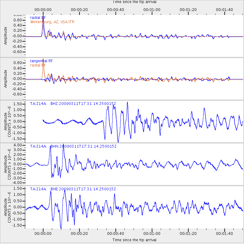
Signal To Noise
| Channel | StoN | STA | LTA |
| TA:Z14A: :BHN:20090311T17:31:14.250015Z | 8.247973 | 1.3696819E-6 | 1.6606283E-7 |
| TA:Z14A: :BHE:20090311T17:31:14.250015Z | 5.891467 | 4.5170708E-7 | 7.667141E-8 |
| TA:Z14A: :BHZ:20090311T17:31:14.250015Z | 4.4189124 | 4.973119E-7 | 1.1254169E-7 |
| Arrivals |
| Ps | 4.3 SECOND |
| PpPs | 11 SECOND |
| PsPs/PpSs | 15 SECOND |


