You are here: Home > Network List > AV - Alaska Volcano Observatory Stations List
> Station STLK Strandline Lake, Regional Station, Alaska > Earthquake Result Viewer
STLK Strandline Lake, Regional Station, Alaska - Earthquake Result Viewer
| Earthquake location: |
Tonga Islands |
| Earthquake latitude/longitude: |
-20.5/-173.8 |
| Earthquake time(UTC): |
2018/11/10 (314) 08:33:16 GMT |
| Earthquake Depth: |
10 km |
| Earthquake Magnitude: |
6.2 Mww |
| Earthquake Catalog/Contributor: |
NEIC PDE/us |
|
| Network: |
AV Alaska Volcano Observatory |
| Station: |
STLK Strandline Lake, Regional Station, Alaska |
| Lat/Lon: |
61.50 N/151.83 W |
| Elevation: |
945 m |
|
| Distance: |
83.6 deg |
| Az: |
10.409 deg |
| Baz: |
200.673 deg |
| Ray Param: |
0.046048764 |
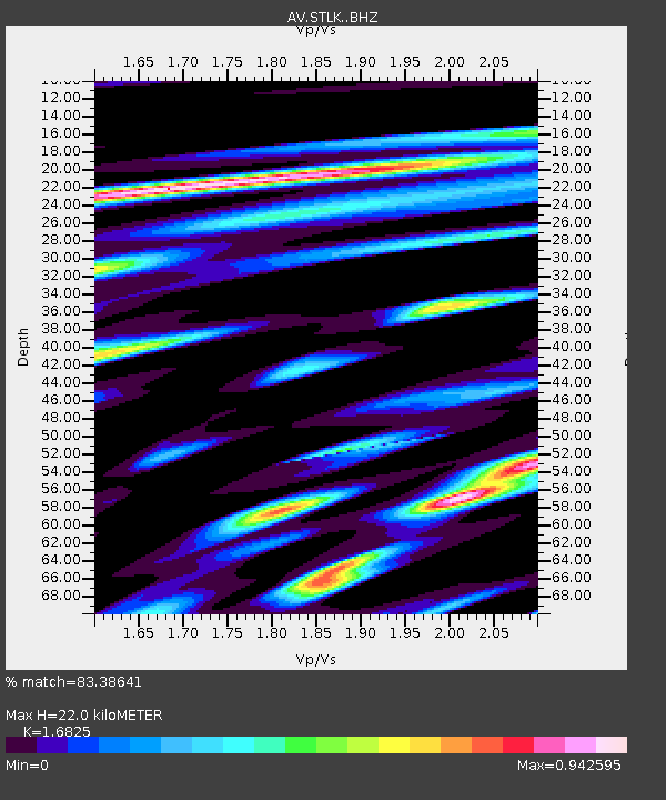
| Estimated Moho Depth: |
22.0 km |
| Estimated Crust Vp/Vs: |
1.68 |
| Assumed Crust Vp: |
6.302 km/s |
| Estimated Crust Vs: |
3.745 km/s |
| Estimated Crust Poisson's Ratio: |
0.23 |
|
| Radial Match: |
83.38641 % |
| Radial Bump: |
400 |
| Transverse Match: |
67.40102 % |
| Transverse Bump: |
400 |
| SOD ConfigId: |
13570011 |
| Insert Time: |
2019-05-01 19:02:35.925 +0000 |
| GWidth: |
2.5 |
| Max Bumps: |
400 |
| Tol: |
0.001 |
|
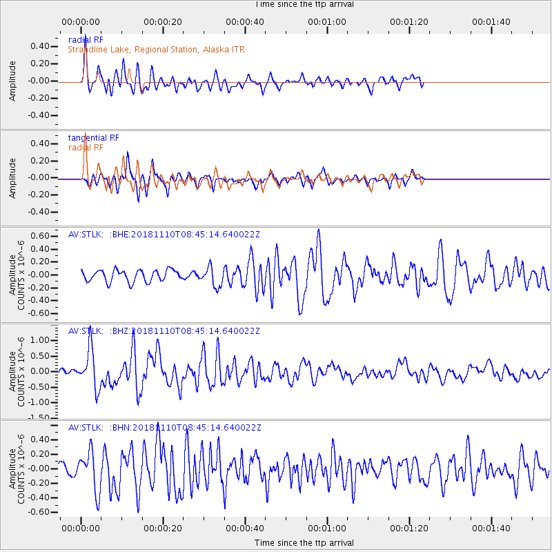
Signal To Noise
| Channel | StoN | STA | LTA |
| AV:STLK: :BHZ:20181110T08:45:14.640022Z | 6.5425777 | 6.4506423E-7 | 9.859482E-8 |
| AV:STLK: :BHN:20181110T08:45:14.640022Z | 3.6426506 | 2.796222E-7 | 7.676339E-8 |
| AV:STLK: :BHE:20181110T08:45:14.640022Z | 1.5295136 | 1.3958775E-7 | 9.1262834E-8 |
| Arrivals |
| Ps | 2.4 SECOND |
| PpPs | 9.1 SECOND |
| PsPs/PpSs | 12 SECOND |


