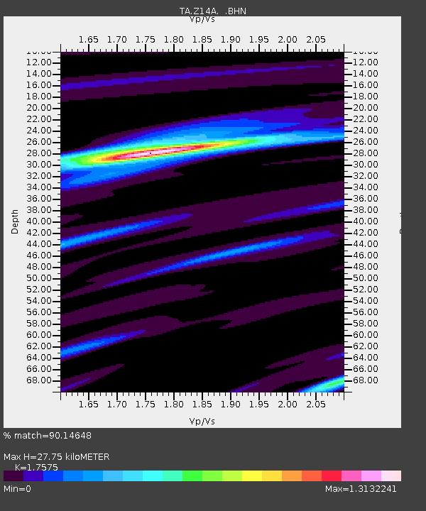
Z14A Wintersburg, AZ, USA - Earthquake Result Viewer

Earthquake location: New Britain Region, P.N.G.
Earthquake latitude/longitude: -5.9/151.0
Earthquake time(UTC): 2006/10/17 (290) 01:25:12 GMT
Earthquake Depth: 32 km
Earthquake Magnitude: 6.4 MB, 6.9 MS, 6.7 MW, 6.6 MW
Earthquake Catalog/Contributor: WHDF/NEIC
Network: TA USArray Transportable Network (new EarthScope stations)
Station: Z14A Wintersburg, AZ, USA
Lat/Lon: 33.36 N/112.95 W
Elevation: 298 m
Distance: 98.3 deg
Az: 57.239 deg
Baz: 268.403 deg
Ray Param: 0.03993957
Estimated Moho Depth: 27.75 km
Estimated Crust Vp/Vs: 1.76
Assumed Crust Vp: 6.264 km/s
Estimated Crust Vs: 3.564 km/s
Estimated Crust Poisson's Ratio: 0.26
Radial Match: 90.14648 %
Radial Bump: 284
Transverse Match: 81.41688 %
Transverse Bump: 400
SOD ConfigId: 2665
Insert Time: 2010-03-06 17:47:49.295 +0000
GWidth: 2.5
Max Bumps: 400
Tol: 0.001

Signal To Noise

ChannelStoNSTALTA
TA:Z14A: :BHN:20061017T01:38:14.823018Z1.14568478.4231175E-87.352038E-8
TA:Z14A: :BHE:20061017T01:38:14.823018Z3.5801923.4225505E-79.559684E-8
TA:Z14A: :BHZ:20061017T01:38:14.823018Z5.67352159.801421E-71.7275727E-7
Arrivals
Ps3.4 SECOND
PpPs12 SECOND
PsPs/PpSs15 SECOND