You are here: Home > Network List > G - GEOSCOPE Stations List
> Station FDF Fort de France, Martinique France > Earthquake Result Viewer
FDF Fort de France, Martinique France - Earthquake Result Viewer
| Earthquake location: |
South Georgia Island Region |
| Earthquake latitude/longitude: |
-55.3/-31.9 |
| Earthquake time(UTC): |
2016/08/19 (232) 07:32:22 GMT |
| Earthquake Depth: |
10 km |
| Earthquake Magnitude: |
7.4 MO |
| Earthquake Catalog/Contributor: |
NEIC PDE/NEIC COMCAT |
|
| Network: |
G GEOSCOPE |
| Station: |
FDF Fort de France, Martinique France |
| Lat/Lon: |
14.73 N/61.14 W |
| Elevation: |
467 m |
|
| Distance: |
74.0 deg |
| Az: |
330.593 deg |
| Baz: |
163.146 deg |
| Ray Param: |
0.052604154 |
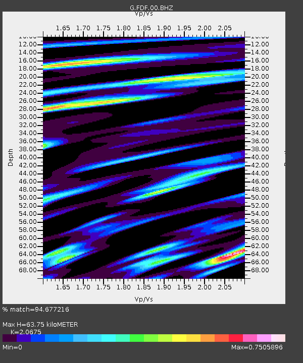
| Estimated Moho Depth: |
63.75 km |
| Estimated Crust Vp/Vs: |
2.07 |
| Assumed Crust Vp: |
5.88 km/s |
| Estimated Crust Vs: |
2.844 km/s |
| Estimated Crust Poisson's Ratio: |
0.35 |
|
| Radial Match: |
94.677216 % |
| Radial Bump: |
400 |
| Transverse Match: |
89.267235 % |
| Transverse Bump: |
400 |
| SOD ConfigId: |
1634031 |
| Insert Time: |
2016-09-02 07:34:30.086 +0000 |
| GWidth: |
2.5 |
| Max Bumps: |
400 |
| Tol: |
0.001 |
|

Signal To Noise
| Channel | StoN | STA | LTA |
| G:FDF:00:BHZ:20160819T07:43:27.549976Z | 25.597652 | 1.0736539E-5 | 4.194345E-7 |
| G:FDF:00:BHN:20160819T07:43:27.549976Z | 6.9617763 | 4.8047027E-6 | 6.901547E-7 |
| G:FDF:00:BHE:20160819T07:43:27.549976Z | 2.5225947 | 1.4611392E-6 | 5.7922074E-7 |
| Arrivals |
| Ps | 12 SECOND |
| PpPs | 32 SECOND |
| PsPs/PpSs | 44 SECOND |


