You are here: Home > Network List > TA - USArray Transportable Network (new EarthScope stations) Stations List
> Station Z14A Wintersburg, AZ, USA > Earthquake Result Viewer
Z14A Wintersburg, AZ, USA - Earthquake Result Viewer
| Earthquake location: |
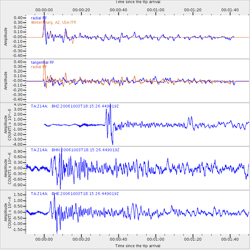
Vanuatu Islands |
| Earthquake latitude/longitude: |
-18.9/169.0 |
| Earthquake time(UTC): |
2006/10/03 (276) 18:03:14 GMT |
| Earthquake Depth: |
171 km |
| Earthquake Magnitude: |
5.9 MB, 6.3 MW, 6.3 MW |
| Earthquake Catalog/Contributor: |
WHDF/NEIC |
|
| Network: |
TA USArray Transportable Network (new EarthScope stations) |
| Station: |
Z14A Wintersburg, AZ, USA |
| Lat/Lon: |
33.36 N/112.95 W |
| Elevation: |
298 m |
|
| Distance: |
90.7 deg |
| Az: |
54.967 deg |
| Baz: |
247.891 deg |
| Ray Param: |
0.041619387 |
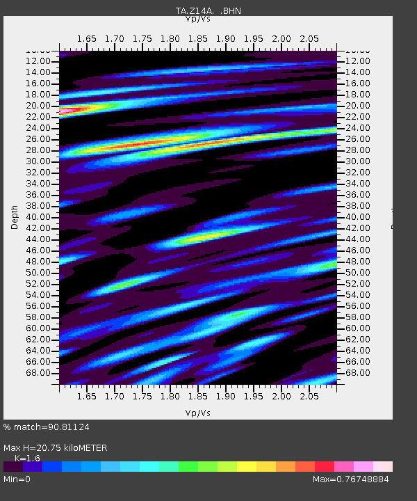
| Estimated Moho Depth: |
20.75 km |
| Estimated Crust Vp/Vs: |
1.60 |
| Assumed Crust Vp: |
6.264 km/s |
| Estimated Crust Vs: |
3.915 km/s |
| Estimated Crust Poisson's Ratio: |
0.18 |
|
| Radial Match: |
90.81124 % |
| Radial Bump: |
400 |
| Transverse Match: |
75.93027 % |
| Transverse Bump: |
400 |
| SOD ConfigId: |
2665 |
| Insert Time: |
2010-03-06 17:48:02.600 +0000 |
| GWidth: |
2.5 |
| Max Bumps: |
400 |
| Tol: |
0.001 |
|
Signal To Noise
| Channel | StoN | STA | LTA |
| TA:Z14A: :BHN:20061003T18:15:26.449019Z | 2.0060525 | 1.7263984E-7 | 8.605949E-8 |
| TA:Z14A: :BHE:20061003T18:15:26.449019Z | 3.3737664 | 3.2810183E-7 | 9.72509E-8 |
| TA:Z14A: :BHZ:20061003T18:15:26.449019Z | 10.856722 | 1.1714321E-6 | 1.07899254E-7 |
| Arrivals |
| Ps | 2.0 SECOND |
| PpPs | 8.4 SECOND |
| PsPs/PpSs | 10 SECOND |


