You are here: Home > Network List > TA - USArray Transportable Network (new EarthScope stations) Stations List
> Station Z14A Wintersburg, AZ, USA > Earthquake Result Viewer
Z14A Wintersburg, AZ, USA - Earthquake Result Viewer
| Earthquake location: |
Central Mid-Atlantic Ridge |
| Earthquake latitude/longitude: |
7.3/-34.7 |
| Earthquake time(UTC): |
2006/09/30 (273) 12:47:22 GMT |
| Earthquake Depth: |
10 km |
| Earthquake Magnitude: |
5.6 MB, 5.0 MS, 5.5 MW |
| Earthquake Catalog/Contributor: |
WHDF/NEIC |
|
| Network: |
TA USArray Transportable Network (new EarthScope stations) |
| Station: |
Z14A Wintersburg, AZ, USA |
| Lat/Lon: |
33.36 N/112.95 W |
| Elevation: |
298 m |
|
| Distance: |
76.3 deg |
| Az: |
302.477 deg |
| Baz: |
90.285 deg |
| Ray Param: |
0.05111183 |
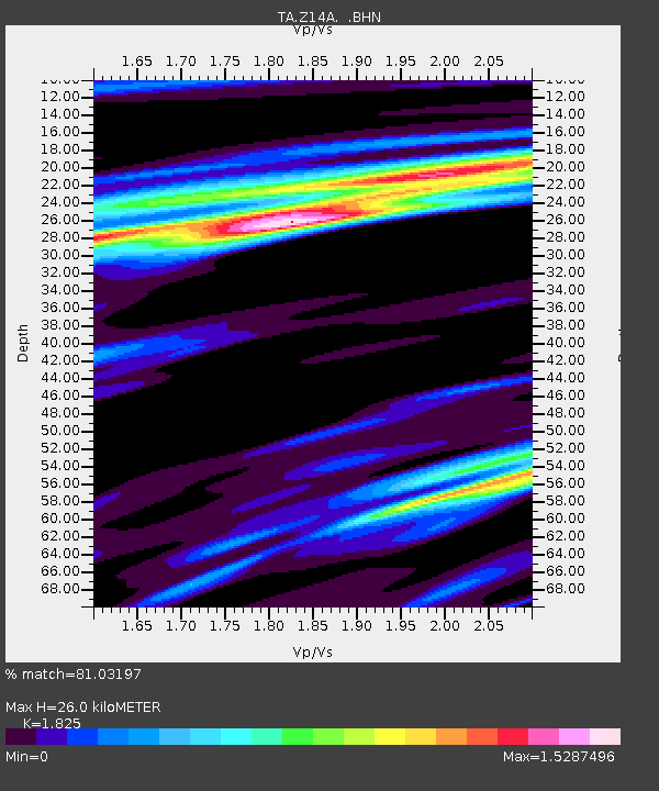
| Estimated Moho Depth: |
26.0 km |
| Estimated Crust Vp/Vs: |
1.83 |
| Assumed Crust Vp: |
6.264 km/s |
| Estimated Crust Vs: |
3.432 km/s |
| Estimated Crust Poisson's Ratio: |
0.29 |
|
| Radial Match: |
81.03197 % |
| Radial Bump: |
400 |
| Transverse Match: |
65.7563 % |
| Transverse Bump: |
400 |
| SOD ConfigId: |
2665 |
| Insert Time: |
2010-03-06 17:48:07.279 +0000 |
| GWidth: |
2.5 |
| Max Bumps: |
400 |
| Tol: |
0.001 |
|

Signal To Noise
| Channel | StoN | STA | LTA |
| TA:Z14A: :BHN:20060930T12:58:40.225Z | 1.2866387 | 9.7920136E-8 | 7.610539E-8 |
| TA:Z14A: :BHE:20060930T12:58:40.225Z | 1.7397418 | 9.4780084E-8 | 5.4479397E-8 |
| TA:Z14A: :BHZ:20060930T12:58:40.225Z | 2.8848214 | 2.601543E-7 | 9.0180386E-8 |
| Arrivals |
| Ps | 3.5 SECOND |
| PpPs | 11 SECOND |
| PsPs/PpSs | 15 SECOND |


