You are here: Home > Network List > TA - USArray Transportable Network (new EarthScope stations) Stations List
> Station Z14A Wintersburg, AZ, USA > Earthquake Result Viewer
Z14A Wintersburg, AZ, USA - Earthquake Result Viewer

| Earthquake location: |
Tonga Islands |
| Earthquake latitude/longitude: |
-20.8/-174.2 |
| Earthquake time(UTC): |
2006/05/16 (136) 20:55:47 GMT |
| Earthquake Depth: |
15 km |
| Earthquake Magnitude: |
5.8 MB, 5.6 MS, 5.7 MW |
| Earthquake Catalog/Contributor: |
WHDF/NEIC |
|
| Network: |
TA USArray Transportable Network (new EarthScope stations) |
| Station: |
Z14A Wintersburg, AZ, USA |
| Lat/Lon: |
33.36 N/112.95 W |
| Elevation: |
298 m |
|
| Distance: |
79.4 deg |
| Az: |
48.264 deg |
| Baz: |
236.565 deg |
| Ray Param: |
0.04899863 |
| Estimated Moho Depth: |
27.0 km |
| Estimated Crust Vp/Vs: |
1.83 |
| Assumed Crust Vp: |
6.264 km/s |
| Estimated Crust Vs: |
3.427 km/s |
| Estimated Crust Poisson's Ratio: |
0.29 |
|
| Radial Match: |
85.20941 % |
| Radial Bump: |
400 |
| Transverse Match: |
50.618015 % |
| Transverse Bump: |
400 |
| SOD ConfigId: |
2669 |
| Insert Time: |
2010-03-06 17:48:36.229 +0000 |
| GWidth: |
2.5 |
| Max Bumps: |
400 |
| Tol: |
0.001 |
|
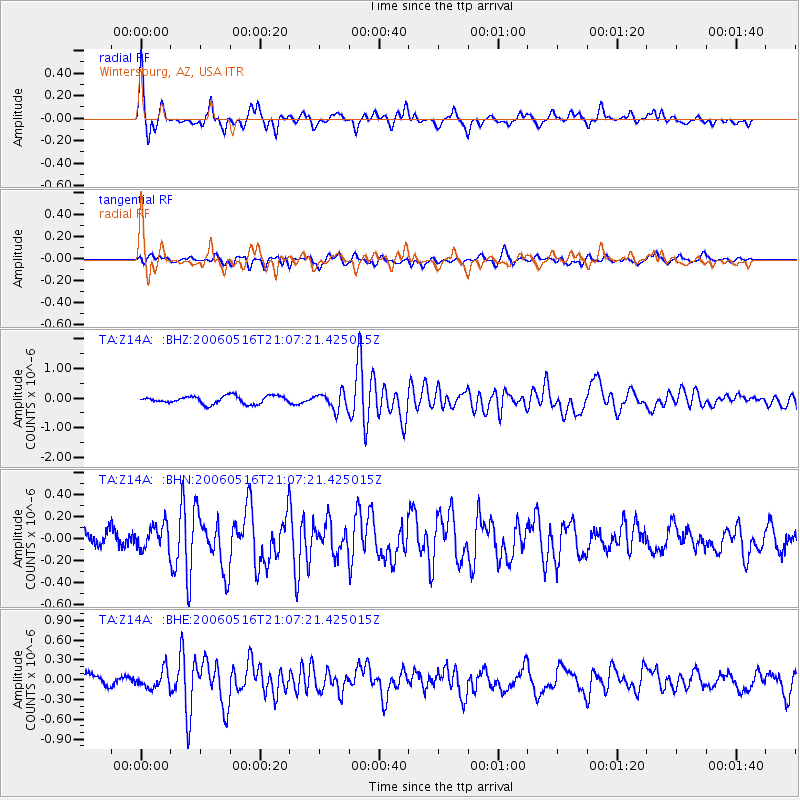
Signal To Noise
| Channel | StoN | STA | LTA |
| TA:Z14A: :BHN:20060516T21:07:21.425015Z | 0.90380204 | 1.1404909E-7 | 1.2618813E-7 |
| TA:Z14A: :BHE:20060516T21:07:21.425015Z | 0.9919662 | 1.3596645E-7 | 1.3706763E-7 |
| TA:Z14A: :BHZ:20060516T21:07:21.425015Z | 2.2600172 | 2.9501115E-7 | 1.3053491E-7 |
| Arrivals |
| Ps | 3.7 SECOND |
| PpPs | 12 SECOND |
| PsPs/PpSs | 16 SECOND |


