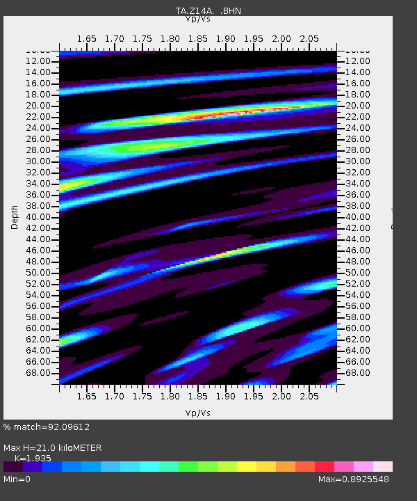
Z14A Wintersburg, AZ, USA - Earthquake Result Viewer
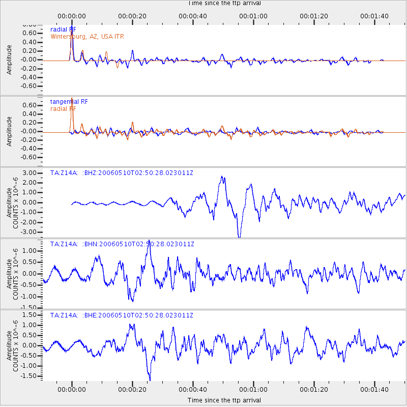
Earthquake location: Fox Islands, Aleutian Islands
Earthquake latitude/longitude: 52.5/-169.3
Earthquake time(UTC): 2006/05/10 (130) 02:42:51 GMT
Earthquake Depth: 18 km
Earthquake Magnitude: 6.1 MB, 6.2 MS, 6.4 MW, 6.3 MW
Earthquake Catalog/Contributor: WHDF/NEIC
Network: TA USArray Transportable Network (new EarthScope stations)
Station: Z14A Wintersburg, AZ, USA
Lat/Lon: 33.36 N/112.95 W
Elevation: 298 m
Distance: 44.2 deg
Az: 92.708 deg
Baz: 313.163 deg
Ray Param: 0.07204475
Estimated Moho Depth: 21.0 km
Estimated Crust Vp/Vs: 1.93
Assumed Crust Vp: 6.264 km/s
Estimated Crust Vs: 3.237 km/s
Estimated Crust Poisson's Ratio: 0.32
Radial Match: 92.09612 %
Radial Bump: 400
Transverse Match: 60.361782 %
Transverse Bump: 400
SOD ConfigId: 2669
Insert Time: 2010-03-06 17:48:43.560 +0000
GWidth: 2.5
Max Bumps: 400
Tol: 0.001

Signal To Noise

ChannelStoNSTALTA
TA:Z14A: :BHN:20060510T02:50:28.023011Z1.1092221.8127454E-71.6342494E-7
TA:Z14A: :BHE:20060510T02:50:28.023011Z1.17465261.6724887E-71.4238157E-7
TA:Z14A: :BHZ:20060510T02:50:28.023011Z2.6769312.962059E-71.106513E-7
Arrivals
Ps3.3 SECOND
PpPs9.3 SECOND
PsPs/PpSs13 SECOND