You are here: Home > Network List > TA - USArray Transportable Network (new EarthScope stations) Stations List
> Station Z14A Wintersburg, AZ, USA > Earthquake Result Viewer
Z14A Wintersburg, AZ, USA - Earthquake Result Viewer
| Earthquake location: |
Fiji Islands Region |
| Earthquake latitude/longitude: |
-17.5/-178.7 |
| Earthquake time(UTC): |
2006/06/09 (160) 05:58:27 GMT |
| Earthquake Depth: |
564 km |
| Earthquake Magnitude: |
5.3 MB, 6.1 MW, 6.1 MW |
| Earthquake Catalog/Contributor: |
WHDF/NEIC |
|
| Network: |
TA USArray Transportable Network (new EarthScope stations) |
| Station: |
Z14A Wintersburg, AZ, USA |
| Lat/Lon: |
33.36 N/112.95 W |
| Elevation: |
298 m |
|
| Distance: |
80.6 deg |
| Az: |
50.693 deg |
| Baz: |
241.903 deg |
| Ray Param: |
0.046464346 |
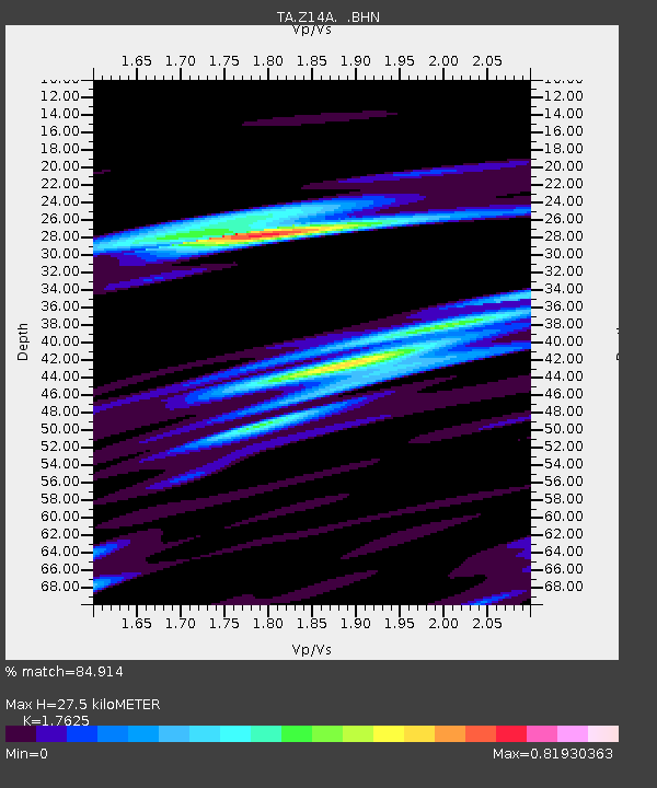
| Estimated Moho Depth: |
27.5 km |
| Estimated Crust Vp/Vs: |
1.76 |
| Assumed Crust Vp: |
6.264 km/s |
| Estimated Crust Vs: |
3.554 km/s |
| Estimated Crust Poisson's Ratio: |
0.26 |
|
| Radial Match: |
84.914 % |
| Radial Bump: |
400 |
| Transverse Match: |
65.71394 % |
| Transverse Bump: |
400 |
| SOD ConfigId: |
2669 |
| Insert Time: |
2010-03-06 17:48:48.141 +0000 |
| GWidth: |
2.5 |
| Max Bumps: |
400 |
| Tol: |
0.001 |
|

Signal To Noise
| Channel | StoN | STA | LTA |
| TA:Z14A: :BHN:20060609T06:09:10.824016Z | 2.9761949 | 1.6425622E-7 | 5.5190007E-8 |
| TA:Z14A: :BHE:20060609T06:09:10.824016Z | 4.1043344 | 2.6943775E-7 | 6.564713E-8 |
| TA:Z14A: :BHZ:20060609T06:09:10.824016Z | 9.340719 | 7.400008E-7 | 7.922311E-8 |
| Arrivals |
| Ps | 3.4 SECOND |
| PpPs | 12 SECOND |
| PsPs/PpSs | 15 SECOND |


