You are here: Home > Network List > GT - Global Telemetered Seismograph Network (USAF/USGS) Stations List
> Station LBTB Lobatse, Botswana, Africa > Earthquake Result Viewer
LBTB Lobatse, Botswana, Africa - Earthquake Result Viewer

| Earthquake location: |
South Georgia Island Region |
| Earthquake latitude/longitude: |
-55.3/-31.9 |
| Earthquake time(UTC): |
2016/08/19 (232) 07:32:22 GMT |
| Earthquake Depth: |
10 km |
| Earthquake Magnitude: |
7.4 MO |
| Earthquake Catalog/Contributor: |
NEIC PDE/NEIC COMCAT |
|
| Network: |
GT Global Telemetered Seismograph Network (USAF/USGS) |
| Station: |
LBTB Lobatse, Botswana, Africa |
| Lat/Lon: |
25.02 S/25.60 E |
| Elevation: |
1128 m |
|
| Distance: |
51.4 deg |
| Az: |
78.234 deg |
| Baz: |
218.057 deg |
| Ray Param: |
0.067414954 |
| Estimated Moho Depth: |
20.75 km |
| Estimated Crust Vp/Vs: |
1.73 |
| Assumed Crust Vp: |
6.459 km/s |
| Estimated Crust Vs: |
3.734 km/s |
| Estimated Crust Poisson's Ratio: |
0.25 |
|
| Radial Match: |
98.119865 % |
| Radial Bump: |
303 |
| Transverse Match: |
87.61887 % |
| Transverse Bump: |
400 |
| SOD ConfigId: |
1634031 |
| Insert Time: |
2016-09-02 07:35:01.486 +0000 |
| GWidth: |
2.5 |
| Max Bumps: |
400 |
| Tol: |
0.001 |
|
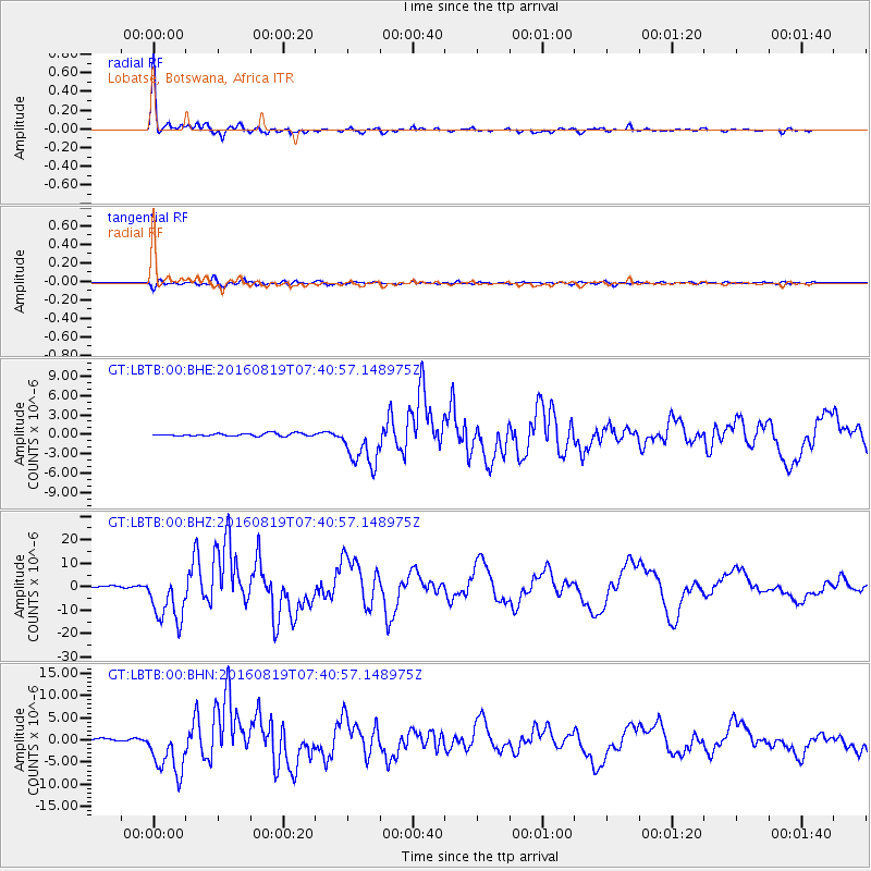
Signal To Noise
| Channel | StoN | STA | LTA |
| GT:LBTB:00:BHZ:20160819T07:40:57.148975Z | 33.450283 | 1.1014206E-5 | 3.2927093E-7 |
| GT:LBTB:00:BHN:20160819T07:40:57.148975Z | 23.70584 | 5.607438E-6 | 2.3654249E-7 |
| GT:LBTB:00:BHE:20160819T07:40:57.148975Z | 17.006403 | 3.5244063E-6 | 2.0723996E-7 |
| Arrivals |
| Ps | 2.5 SECOND |
| PpPs | 8.3 SECOND |
| PsPs/PpSs | 11 SECOND |


