You are here: Home > Network List > TA - USArray Transportable Network (new EarthScope stations) Stations List
> Station Z14A Wintersburg, AZ, USA > Earthquake Result Viewer
Z14A Wintersburg, AZ, USA - Earthquake Result Viewer
| Earthquake location: |
Kuril Islands |
| Earthquake latitude/longitude: |
50.8/155.0 |
| Earthquake time(UTC): |
2009/04/21 (111) 05:26:11 GMT |
| Earthquake Depth: |
152 km |
| Earthquake Magnitude: |
6.0 MB, 6.2 MW, 6.2 MW |
| Earthquake Catalog/Contributor: |
WHDF/NEIC |
|
| Network: |
TA USArray Transportable Network (new EarthScope stations) |
| Station: |
Z14A Wintersburg, AZ, USA |
| Lat/Lon: |
33.36 N/112.95 W |
| Elevation: |
298 m |
|
| Distance: |
66.2 deg |
| Az: |
66.125 deg |
| Baz: |
316.142 deg |
| Ray Param: |
0.057371 |
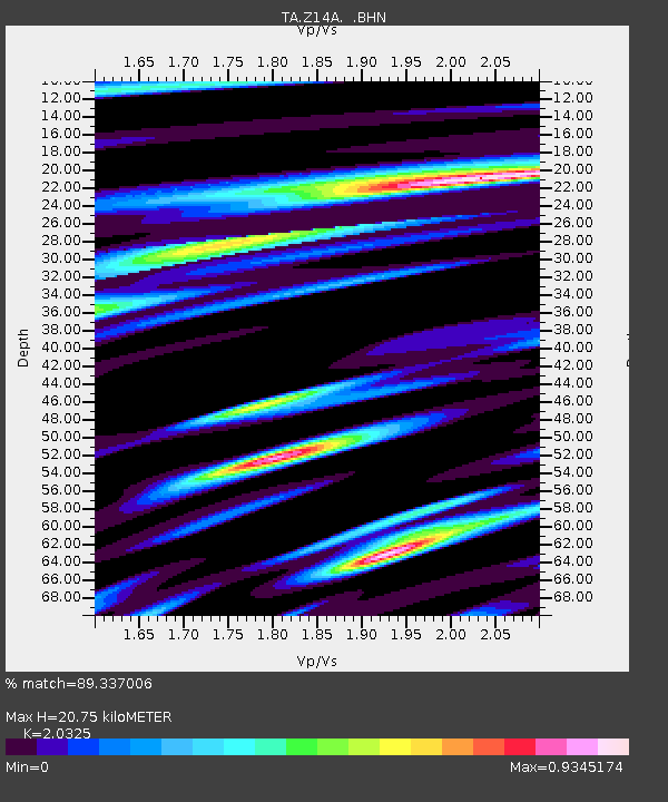
| Estimated Moho Depth: |
20.75 km |
| Estimated Crust Vp/Vs: |
2.03 |
| Assumed Crust Vp: |
6.264 km/s |
| Estimated Crust Vs: |
3.082 km/s |
| Estimated Crust Poisson's Ratio: |
0.34 |
|
| Radial Match: |
89.337006 % |
| Radial Bump: |
400 |
| Transverse Match: |
69.44581 % |
| Transverse Bump: |
400 |
| SOD ConfigId: |
2760 |
| Insert Time: |
2010-03-06 17:49:22.143 +0000 |
| GWidth: |
2.5 |
| Max Bumps: |
400 |
| Tol: |
0.001 |
|

Signal To Noise
| Channel | StoN | STA | LTA |
| TA:Z14A: :BHN:20090421T05:36:11.800029Z | 12.498873 | 1.5343106E-6 | 1.2275592E-7 |
| TA:Z14A: :BHE:20090421T05:36:11.800029Z | 2.562392 | 3.8618649E-7 | 1.5071328E-7 |
| TA:Z14A: :BHZ:20090421T05:36:11.800029Z | 4.9565105 | 5.3269747E-7 | 1.074743E-7 |
| Arrivals |
| Ps | 3.5 SECOND |
| PpPs | 9.7 SECOND |
| PsPs/PpSs | 13 SECOND |


