You are here: Home > Network List > TA - USArray Transportable Network (new EarthScope stations) Stations List
> Station D25K Kavik River, AK, USA > Earthquake Result Viewer
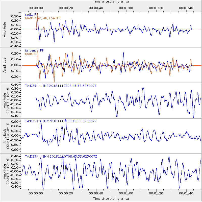
D25K Kavik River, AK, USA - Earthquake Result Viewer
*The percent match for this event was below the threshold and hence no stack was calculated.
| Earthquake location: |
Tonga Islands |
| Earthquake latitude/longitude: |
-20.5/-173.8 |
| Earthquake time(UTC): |
2018/11/10 (314) 08:33:16 GMT |
| Earthquake Depth: |
10 km |
| Earthquake Magnitude: |
6.2 Mww |
| Earthquake Catalog/Contributor: |
NEIC PDE/us |
|
| Network: |
TA USArray Transportable Network (new EarthScope stations) |
| Station: |
D25K Kavik River, AK, USA |
| Lat/Lon: |
69.32 N/146.38 W |
| Elevation: |
770 m |
|
| Distance: |
91.8 deg |
| Az: |
9.426 deg |
| Baz: |
205.604 deg |
| Ray Param: |
$rayparam |
*The percent match for this event was below the threshold and hence was not used in the summary stack. |
|
| Radial Match: |
71.20299 % |
| Radial Bump: |
400 |
| Transverse Match: |
59.74054 % |
| Transverse Bump: |
400 |
| SOD ConfigId: |
13570011 |
| Insert Time: |
2019-05-01 19:08:51.288 +0000 |
| GWidth: |
2.5 |
| Max Bumps: |
400 |
| Tol: |
0.001 |
|
Signal To Noise
| Channel | StoN | STA | LTA |
| TA:D25K: :BHZ:20181110T08:45:53.625007Z | 3.941327 | 3.9961915E-7 | 1.0139203E-7 |
| TA:D25K: :BHN:20181110T08:45:53.625007Z | 1.700836 | 2.1799644E-7 | 1.2817019E-7 |
| TA:D25K: :BHE:20181110T08:45:53.625007Z | 0.57848465 | 5.60353E-8 | 9.686566E-8 |
| Arrivals |
| Ps | |
| PpPs | |
| PsPs/PpSs | |


