You are here: Home > Network List > TA - USArray Transportable Network (new EarthScope stations) Stations List
> Station F21K Alatna River, AK, USA > Earthquake Result Viewer
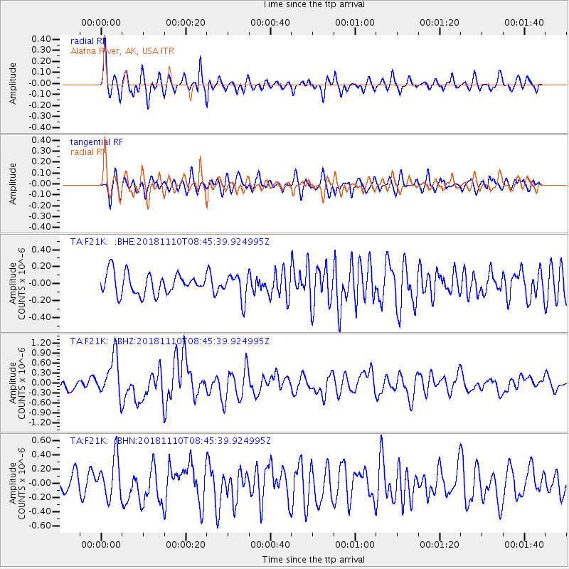
F21K Alatna River, AK, USA - Earthquake Result Viewer
*The percent match for this event was below the threshold and hence no stack was calculated.
| Earthquake location: |
Tonga Islands |
| Earthquake latitude/longitude: |
-20.5/-173.8 |
| Earthquake time(UTC): |
2018/11/10 (314) 08:33:16 GMT |
| Earthquake Depth: |
10 km |
| Earthquake Magnitude: |
6.2 Mww |
| Earthquake Catalog/Contributor: |
NEIC PDE/us |
|
| Network: |
TA USArray Transportable Network (new EarthScope stations) |
| Station: |
F21K Alatna River, AK, USA |
| Lat/Lon: |
67.22 N/153.48 W |
| Elevation: |
597 m |
|
| Distance: |
88.8 deg |
| Az: |
7.779 deg |
| Baz: |
199.013 deg |
| Ray Param: |
$rayparam |
*The percent match for this event was below the threshold and hence was not used in the summary stack. |
|
| Radial Match: |
73.55909 % |
| Radial Bump: |
400 |
| Transverse Match: |
65.0436 % |
| Transverse Bump: |
400 |
| SOD ConfigId: |
13570011 |
| Insert Time: |
2019-05-01 19:09:05.805 +0000 |
| GWidth: |
2.5 |
| Max Bumps: |
400 |
| Tol: |
0.001 |
|
Signal To Noise
| Channel | StoN | STA | LTA |
| TA:F21K: :BHZ:20181110T08:45:39.924995Z | 4.270594 | 6.285265E-7 | 1.4717541E-7 |
| TA:F21K: :BHN:20181110T08:45:39.924995Z | 2.1435623 | 2.9447324E-7 | 1.3737565E-7 |
| TA:F21K: :BHE:20181110T08:45:39.924995Z | 1.039334 | 1.2922655E-7 | 1.2433591E-7 |
| Arrivals |
| Ps | |
| PpPs | |
| PsPs/PpSs | |


