You are here: Home > Network List > TA - USArray Transportable Network (new EarthScope stations) Stations List
> Station F26K Sheenjek River, AK, USA > Earthquake Result Viewer
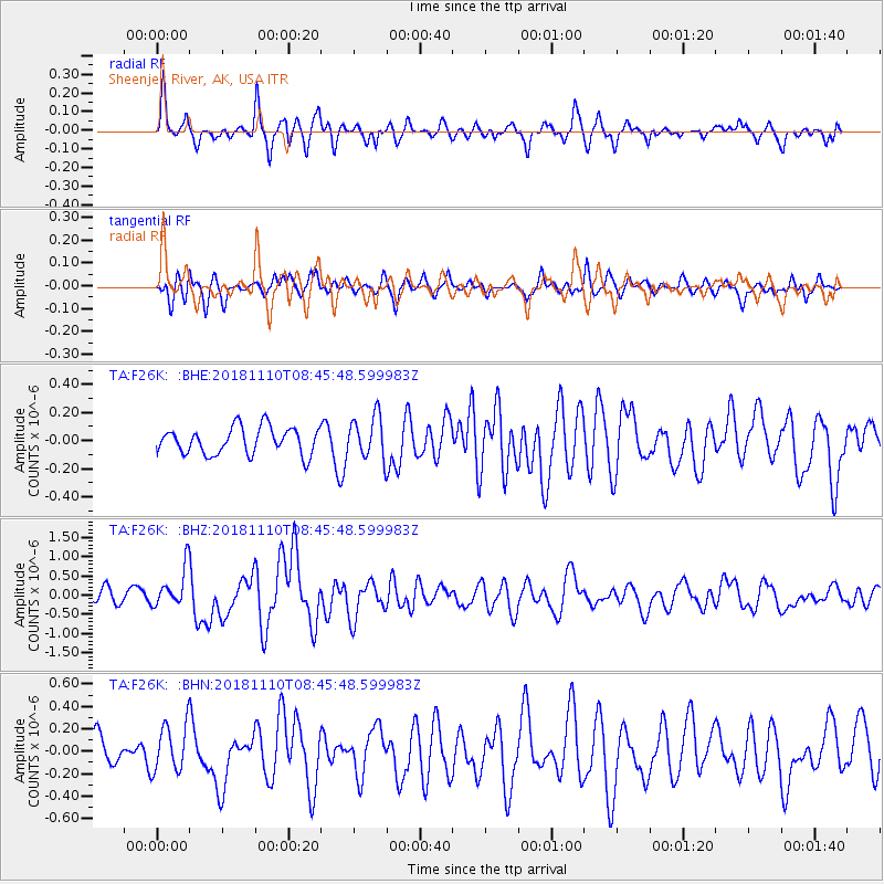
F26K Sheenjek River, AK, USA - Earthquake Result Viewer
*The percent match for this event was below the threshold and hence no stack was calculated.
| Earthquake location: |
Tonga Islands |
| Earthquake latitude/longitude: |
-20.5/-173.8 |
| Earthquake time(UTC): |
2018/11/10 (314) 08:33:16 GMT |
| Earthquake Depth: |
10 km |
| Earthquake Magnitude: |
6.2 Mww |
| Earthquake Catalog/Contributor: |
NEIC PDE/us |
|
| Network: |
TA USArray Transportable Network (new EarthScope stations) |
| Station: |
F26K Sheenjek River, AK, USA |
| Lat/Lon: |
67.69 N/144.15 W |
| Elevation: |
683 m |
|
| Distance: |
90.7 deg |
| Az: |
10.894 deg |
| Baz: |
207.646 deg |
| Ray Param: |
$rayparam |
*The percent match for this event was below the threshold and hence was not used in the summary stack. |
|
| Radial Match: |
71.23192 % |
| Radial Bump: |
367 |
| Transverse Match: |
61.24417 % |
| Transverse Bump: |
400 |
| SOD ConfigId: |
13570011 |
| Insert Time: |
2019-05-01 19:09:08.960 +0000 |
| GWidth: |
2.5 |
| Max Bumps: |
400 |
| Tol: |
0.001 |
|
Signal To Noise
| Channel | StoN | STA | LTA |
| TA:F26K: :BHZ:20181110T08:45:48.599983Z | 3.378165 | 4.927799E-7 | 1.4587208E-7 |
| TA:F26K: :BHN:20181110T08:45:48.599983Z | 2.1899183 | 2.1095204E-7 | 9.6328726E-8 |
| TA:F26K: :BHE:20181110T08:45:48.599983Z | 1.7569112 | 1.691938E-7 | 9.6301854E-8 |
| Arrivals |
| Ps | |
| PpPs | |
| PsPs/PpSs | |


