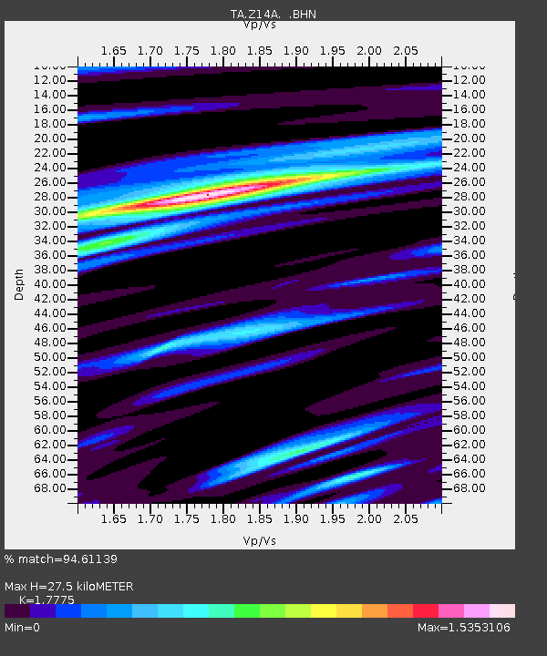
Z14A Wintersburg, AZ, USA - Earthquake Result Viewer
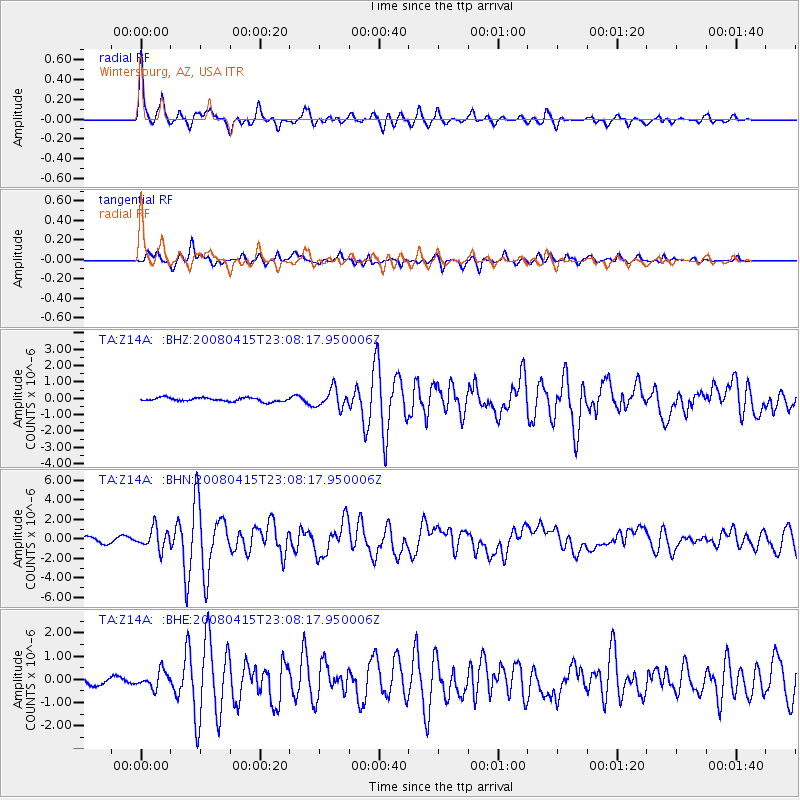
Earthquake location: Andreanof Islands, Aleutian Is.
Earthquake latitude/longitude: 51.9/-179.4
Earthquake time(UTC): 2008/04/15 (106) 22:59:51 GMT
Earthquake Depth: 10 km
Earthquake Magnitude: 6.1 MB, 6.4 MS, 6.4 MW, 6.4 MW
Earthquake Catalog/Contributor: WHDF/NEIC
Network: TA USArray Transportable Network (new EarthScope stations)
Station: Z14A Wintersburg, AZ, USA
Lat/Lon: 33.36 N/112.95 W
Elevation: 298 m
Distance: 50.4 deg
Az: 84.282 deg
Baz: 312.488 deg
Ray Param: 0.06806533
Estimated Moho Depth: 27.5 km
Estimated Crust Vp/Vs: 1.78
Assumed Crust Vp: 6.264 km/s
Estimated Crust Vs: 3.524 km/s
Estimated Crust Poisson's Ratio: 0.27
Radial Match: 94.61139 %
Radial Bump: 400
Transverse Match: 83.80948 %
Transverse Bump: 400
SOD ConfigId: 2504
Insert Time: 2010-03-06 17:49:44.299 +0000
GWidth: 2.5
Max Bumps: 400
Tol: 0.001

Signal To Noise

ChannelStoNSTALTA
TA:Z14A: :BHN:20080415T23:08:17.950006Z4.46560761.0521545E-62.3561284E-7
TA:Z14A: :BHE:20080415T23:08:17.950006Z2.31834963.563666E-71.5371563E-7
TA:Z14A: :BHZ:20080415T23:08:17.950006Z5.0883135.6972743E-71.11967836E-7
Arrivals
Ps3.6 SECOND
PpPs12 SECOND
PsPs/PpSs15 SECOND