You are here: Home > Network List > IU - Global Seismograph Network (GSN - IRIS/USGS) Stations List
> Station PAYG Puerto Ayora, Galapagos Islands > Earthquake Result Viewer
PAYG Puerto Ayora, Galapagos Islands - Earthquake Result Viewer
| Earthquake location: |
South Georgia Island Region |
| Earthquake latitude/longitude: |
-55.3/-31.9 |
| Earthquake time(UTC): |
2016/08/19 (232) 07:32:22 GMT |
| Earthquake Depth: |
10 km |
| Earthquake Magnitude: |
7.4 MO |
| Earthquake Catalog/Contributor: |
NEIC PDE/NEIC COMCAT |
|
| Network: |
IU Global Seismograph Network (GSN - IRIS/USGS) |
| Station: |
PAYG Puerto Ayora, Galapagos Islands |
| Lat/Lon: |
0.67 S/90.29 W |
| Elevation: |
270 m |
|
| Distance: |
72.0 deg |
| Az: |
296.479 deg |
| Baz: |
149.243 deg |
| Ray Param: |
0.05396715 |
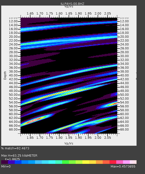
| Estimated Moho Depth: |
63.25 km |
| Estimated Crust Vp/Vs: |
1.66 |
| Assumed Crust Vp: |
4.802 km/s |
| Estimated Crust Vs: |
2.888 km/s |
| Estimated Crust Poisson's Ratio: |
0.22 |
|
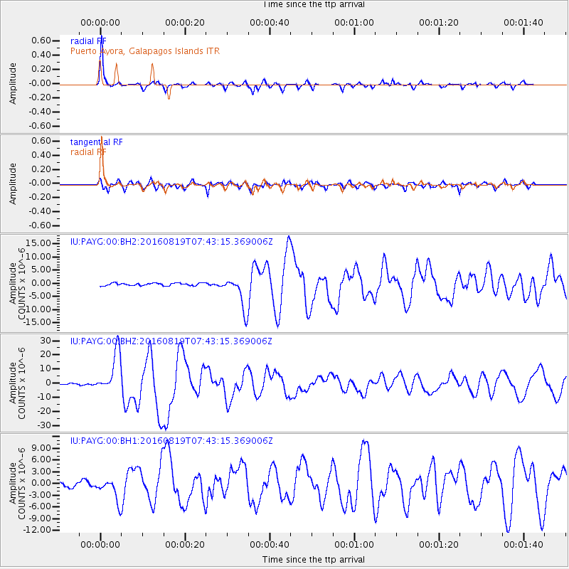
| Radial Match: |
92.4673 % |
| Radial Bump: |
284 |
| Transverse Match: |
82.92872 % |
| Transverse Bump: |
400 |
| SOD ConfigId: |
1634031 |
| Insert Time: |
2016-09-02 07:35:40.863 +0000 |
| GWidth: |
2.5 |
| Max Bumps: |
400 |
| Tol: |
0.001 |
|
Signal To Noise
| Channel | StoN | STA | LTA |
| IU:PAYG:00:BHZ:20160819T07:43:15.369006Z | 24.204777 | 1.5005439E-5 | 6.199371E-7 |
| IU:PAYG:00:BH1:20160819T07:43:15.369006Z | 4.8965907 | 2.9788616E-6 | 6.0835424E-7 |
| IU:PAYG:00:BH2:20160819T07:43:15.369006Z | 13.922247 | 6.5632375E-6 | 4.7142086E-7 |
| Arrivals |
| Ps | 8.9 SECOND |
| PpPs | 34 SECOND |
| PsPs/PpSs | 43 SECOND |


