You are here: Home > Network List > TS - TERRAscope (Southern California Seismic Network) Stations List
> Station BAR Barrett Dam, California, USA > Earthquake Result Viewer
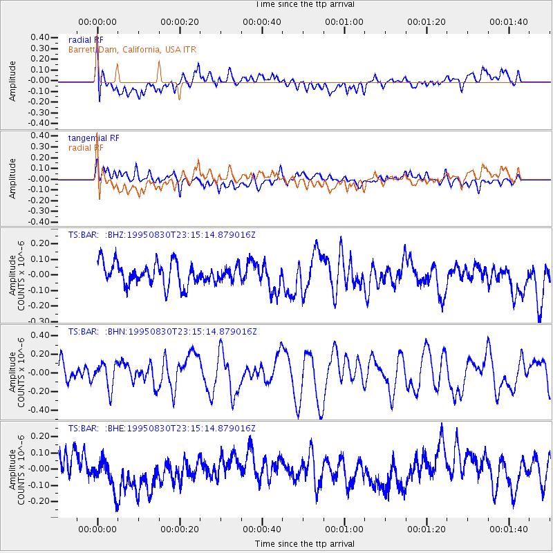
BAR Barrett Dam, California, USA - Earthquake Result Viewer
*The percent match for this event was below the threshold and hence no stack was calculated.
| Earthquake location: |
Tonga Islands |
| Earthquake latitude/longitude: |
-19.3/-173.6 |
| Earthquake time(UTC): |
1995/08/30 (242) 23:04:07 GMT |
| Earthquake Depth: |
33 km |
| Earthquake Magnitude: |
5.8 MS, 5.1 MB, 5.8 UNKNOWN, 5.8 MW |
| Earthquake Catalog/Contributor: |
WHDF/NEIC |
|
| Network: |
TS TERRAscope (Southern California Seismic Network) |
| Station: |
BAR Barrett Dam, California, USA |
| Lat/Lon: |
32.68 N/116.67 W |
| Elevation: |
548 m |
|
| Distance: |
75.0 deg |
| Az: |
46.987 deg |
| Baz: |
234.972 deg |
| Ray Param: |
$rayparam |
*The percent match for this event was below the threshold and hence was not used in the summary stack. |
|
| Radial Match: |
59.444233 % |
| Radial Bump: |
400 |
| Transverse Match: |
48.532974 % |
| Transverse Bump: |
400 |
| SOD ConfigId: |
4480 |
| Insert Time: |
2010-02-26 14:00:25.554 +0000 |
| GWidth: |
2.5 |
| Max Bumps: |
400 |
| Tol: |
0.001 |
|
Signal To Noise
| Channel | StoN | STA | LTA |
| TS:BAR: :BHN:19950830T23:15:14.879016Z | 1.3361592 | 1.3620047E-7 | 1.0193431E-7 |
| TS:BAR: :BHE:19950830T23:15:14.879016Z | 1.9121202 | 1.2683866E-7 | 6.633404E-8 |
| TS:BAR: :BHZ:19950830T23:15:14.879016Z | 0.56891924 | 4.2876014E-8 | 7.536397E-8 |
| Arrivals |
| Ps | |
| PpPs | |
| PsPs/PpSs | |


