You are here: Home > Network List > TA - USArray Transportable Network (new EarthScope stations) Stations List
> Station Z14A Wintersburg, AZ, USA > Earthquake Result Viewer
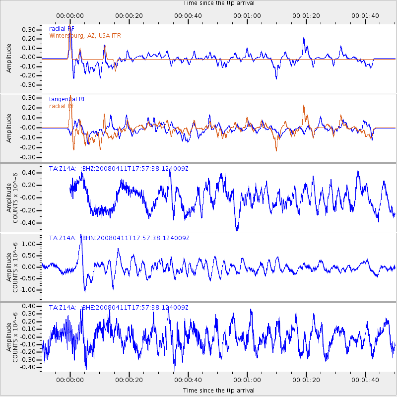
Z14A Wintersburg, AZ, USA - Earthquake Result Viewer
*The percent match for this event was below the threshold and hence no stack was calculated.
| Earthquake location: |
Loyalty Islands |
| Earthquake latitude/longitude: |
-20.4/168.8 |
| Earthquake time(UTC): |
2008/04/11 (102) 17:45:05 GMT |
| Earthquake Depth: |
35 km |
| Earthquake Magnitude: |
5.7 MB, 5.9 MS, 6.0 MW, 6.0 MW |
| Earthquake Catalog/Contributor: |
WHDF/NEIC |
|
| Network: |
TA USArray Transportable Network (new EarthScope stations) |
| Station: |
Z14A Wintersburg, AZ, USA |
| Lat/Lon: |
33.36 N/112.95 W |
| Elevation: |
298 m |
|
| Distance: |
91.7 deg |
| Az: |
55.053 deg |
| Baz: |
246.74 deg |
| Ray Param: |
$rayparam |
*The percent match for this event was below the threshold and hence was not used in the summary stack. |
|
| Radial Match: |
70.77145 % |
| Radial Bump: |
400 |
| Transverse Match: |
66.80549 % |
| Transverse Bump: |
400 |
| SOD ConfigId: |
2504 |
| Insert Time: |
2010-03-06 17:50:17.337 +0000 |
| GWidth: |
2.5 |
| Max Bumps: |
400 |
| Tol: |
0.001 |
|
Signal To Noise
| Channel | StoN | STA | LTA |
| TA:Z14A: :BHN:20080411T17:57:38.124009Z | 3.6053982 | 5.6581865E-7 | 1.5693652E-7 |
| TA:Z14A: :BHE:20080411T17:57:38.124009Z | 1.3848258 | 1.6606607E-7 | 1.1991838E-7 |
| TA:Z14A: :BHZ:20080411T17:57:38.124009Z | 0.8434644 | 1.5427138E-7 | 1.8290206E-7 |
| Arrivals |
| Ps | |
| PpPs | |
| PsPs/PpSs | |


