You are here: Home > Network List > US - United States National Seismic Network Stations List
> Station MNTX Cornudas Mountains, Texas, USA > Earthquake Result Viewer
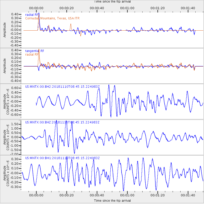
MNTX Cornudas Mountains, Texas, USA - Earthquake Result Viewer
*The percent match for this event was below the threshold and hence no stack was calculated.
| Earthquake location: |
Tonga Islands |
| Earthquake latitude/longitude: |
-20.5/-173.8 |
| Earthquake time(UTC): |
2018/11/10 (314) 08:33:16 GMT |
| Earthquake Depth: |
10 km |
| Earthquake Magnitude: |
6.2 Mww |
| Earthquake Catalog/Contributor: |
NEIC PDE/us |
|
| Network: |
US United States National Seismic Network |
| Station: |
MNTX Cornudas Mountains, Texas, USA |
| Lat/Lon: |
31.70 N/105.38 W |
| Elevation: |
404 m |
|
| Distance: |
83.6 deg |
| Az: |
52.91 deg |
| Baz: |
241.292 deg |
| Ray Param: |
$rayparam |
*The percent match for this event was below the threshold and hence was not used in the summary stack. |
|
| Radial Match: |
80.58532 % |
| Radial Bump: |
330 |
| Transverse Match: |
60.257683 % |
| Transverse Bump: |
400 |
| SOD ConfigId: |
13570011 |
| Insert Time: |
2019-05-01 19:12:01.946 +0000 |
| GWidth: |
2.5 |
| Max Bumps: |
400 |
| Tol: |
0.001 |
|
Signal To Noise
| Channel | StoN | STA | LTA |
| US:MNTX:00:BHZ:20181110T08:45:15.224983Z | 0.85009706 | 1.2738283E-7 | 1.4984505E-7 |
| US:MNTX:00:BH1:20181110T08:45:15.224983Z | 1.8434982 | 1.4220437E-7 | 7.713833E-8 |
| US:MNTX:00:BH2:20181110T08:45:15.224983Z | 0.5597322 | 9.752508E-8 | 1.7423525E-7 |
| Arrivals |
| Ps | |
| PpPs | |
| PsPs/PpSs | |


